Metepec geodata
Metepec (State of Mexico) is a seat of a second-order administrative division; located in Mexico in America/Mexico_City (GMT-6) time zone. With population of 28,205 people, there are 351 cities with bigger population in this country. Compared to other cities in Mexico, 59.7% of cities are located further ↑North; 58.6% of cities are located further →East and 95.9% of cities have lower elevation than Metepec. Note1


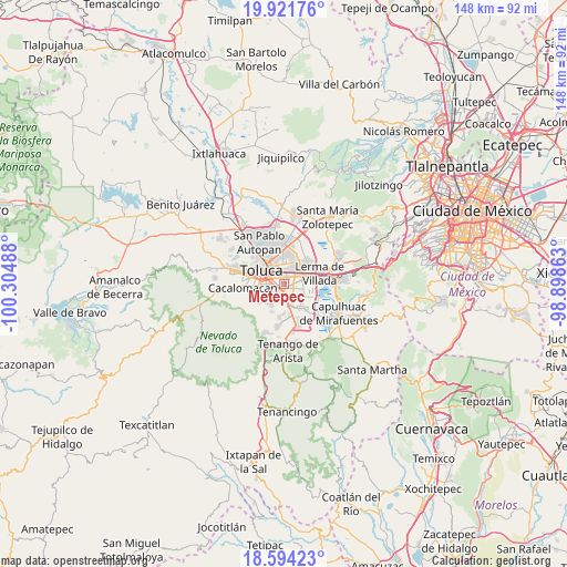
Metepec GPS coordinates[2]
19° 15' 33.624" North, 99° 36' 6.3" West
| Map corner | latitude | longitude |
|---|---|---|
| Upper-left | 19.92176°, | -100.30488° |
| Center: | 19.25934°, | -99.60175° |
| Lower-right: | 18.59423°, | -98.89863° |
| Map W x H: | 147.6×147.6 km | = 91.7×91.7mi |
| max Lat: | 32.7° ⇑59.7% North |
| Metepec: | 19.25934° |
| min Lat: | ⇓40.3% South 14.53588° |
| min Long | Metepec | max Long |
| -117.105° | -99.60175° | -86.73105° |
| W 41.4%⇐ | ⇒58.6% E |
Elevation
Elevation of Metepec is 2623 m = 8606 ft, and this is 1369.3 m = 4492 ft above average elevation for this country.
| Max E: |
3497 m = 11473 ft | 4.1% |
| Metepec | 2623 m 8606 ft | |
| Avg. | 1253.7 m = 4113 ft | |
Min E: |
-1 m = -3 ft | 95.9% |
See also: Mexico elevation on elevation.city.
Geographical zone
Metepec is located in North Torrid zone (between Equator and Tropic of Cancer). Distance of this Northern Tropic circle is 464.5 km =288.6 mi to North.| Distance of | km | miles | from Metepec |
|---|---|---|---|
| North Pole | 7865.6 | 4887.5 | to North |
| Arctic Circle | 5259.7 | 3268.2 | to North |
| Tropic Cancer | 464.5 | 288.6 | to North |
| Equator | 2141.4 | 1330.6 | to South |


Nearby cities:
15 places around Metepec: (largest is in red/bold)
• Atizapán
5.5 km =3.4 mi,  100°
100°
• Barrio Santiaguito
4.1 km =2.5 mi,  214°
214°
• Barrio de la Asunción
4 km =2.5 mi,  150°
150°
• Barrio la Venta
4.1 km =2.5 mi,  240°
240°
• Colonia Llano Grande (El Salitre)
4.3 km =2.7 mi,  111°
111°
• San Bartolomé Tlaltelulco
4.6 km =2.9 mi,  219°
219°
• San Felipe Tlalmimilolpan
4.8 km =3 mi, 242°
• San Francisco Cuaxusco
2.1 km =1.3 mi,  296°
296°
• San Jerónimo Chicahualco
2.8 km =1.7 mi,  19°
19°
• San Jorge Pueblo Nuevo
2.8 km =1.7 mi,  258°
258°
• San Miguel Totocuitlapilco
3.5 km =2.2 mi,  166°
166°
• San Salvador Tizatlalli
1.2 km =0.7 mi,  84°
84°
• Santa María Magdalena Ocotitlán
3.4 km =2.1 mi, 223°
• Santa María Totoltepec
5.3 km =3.3 mi,  10°
10°
• Santa María la Asunción
5.2 km =3.2 mi, 80°
In other languages:
- In Spanish: Municipio de Metepec
- In German: Municipio Metepec
- In Russian: Метепек
- In Chinese: 梅特佩克
Sources, notices
• [Note1] Compared only with cities in Mexico existing in our database
• [Src1] Map data: © OpenStreetMap contributors (CC-BY-SA)
• [Src2] Other city data from geonames.org with taken over terms of usage.
• [Src3] Geographical zone / Annual Mean Temperature by Robert A. Rohde @ Wikipedia
