San Jacinto geodata
San Jacinto (State of Mexico) is a populated place; located in Mexico in America/Mexico_City (GMT-6) time zone. With population of 2,252 people, there are 3905 cities with bigger population in this country. Compared to other cities in Mexico, 57.2% of cities are located further ↑North; 54.4% of cities are located further →East and 98.1% of cities have lower elevation than San Jacinto. Note1


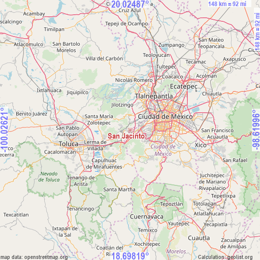
San Jacinto GPS coordinates[2]
19° 21' 46.368" North, 99° 19' 23.088" West
| Map corner | latitude | longitude |
|---|---|---|
| Upper-left | 20.02487°, | -100.02621° |
| Center: | 19.36288°, | -99.32308° |
| Lower-right: | 18.69819°, | -98.61996° |
| Map W x H: | 147.5×147.5 km | = 91.7×91.7mi |
| max Lat: | 32.7° ⇑57.2% North |
| San Jacinto: | 19.36288° |
| min Lat: | ⇓42.8% South 14.53588° |
| min Long | San Jacinto | max Long |
| -117.105° | -99.32308° | -86.73105° |
| W 45.6%⇐ | ⇒54.4% E |
Elevation
Elevation of San Jacinto is 2756 m = 9042 ft, and this is 1502.3 m = 4929 ft above average elevation for this country.
| Max E: |
3497 m = 11473 ft | 1.9% |
| San Jacinto | 2756 m 9042 ft | |
| Avg. | 1253.7 m = 4113 ft | |
Min E: |
-1 m = -3 ft | 98.1% |
See also: Mexico elevation on elevation.city.
Geographical zone
San Jacinto is located in North Torrid zone (between Equator and Tropic of Cancer). Distance of this Northern Tropic circle is 453 km =281.5 mi to North.| Distance of | km | miles | from San Jacinto |
|---|---|---|---|
| North Pole | 7854.1 | 4880.3 | to North |
| Arctic Circle | 5248.2 | 3261.1 | to North |
| Tropic Cancer | 453 | 281.5 | to North |
| Equator | 2153 | 1337.8 | to South |


Nearby cities:
15 places around San Jacinto: (largest is in red/bold)
• Barrio de San Ramón
1.5 km =0.9 mi,  324°
324°
• Cerro de San Francisco
3.1 km =1.9 mi,  285°
285°
• Colonia La Venta
3.4 km =2.1 mi,  158°
158°
• Delegación Cuajimalpa de Morelos
3.4 km =2.1 mi,  78°
78°
• Dos Ríos
2.5 km =1.6 mi,  301°
301°
• El Cerrito
2.8 km =1.7 mi,  252°
252°
• El Mirasol
1.7 km =1.1 mi,  212°
212°
• Huixquilucan
2.9 km =1.8 mi,  263°
263°
• Huixquilucan de Degollado
2.8 km =1.7 mi, 264°
• Jesús del Monte
3.3 km =2.1 mi,  65°
65°
• Paraje la Pera
3 km =1.9 mi,  310°
310°
• San Francisco Ayotuzco
3.6 km =2.2 mi,  275°
275°
• San Juan Yautepec
2.4 km =1.5 mi,  229°
229°
• Santiago Yancuitlalpan
3 km =1.9 mi,  39°
39°
• Zacamulpa
1.2 km =0.7 mi, 227°
Sources, notices
• [Note1] Compared only with cities in Mexico existing in our database
• [Src1] Map data: © OpenStreetMap contributors (CC-BY-SA)
• [Src2] Other city data from geonames.org with taken over terms of usage.
• [Src3] Geographical zone / Annual Mean Temperature by Robert A. Rohde @ Wikipedia
