Jesús del Monte geodata
Jesús del Monte (State of Mexico) is a populated place; located in Mexico in America/Mexico_City (GMT-6) time zone. With population of 23,150 people, there are 440 cities with bigger population in this country. Compared to other cities in Mexico, 56.9% of cities are located further ↑North; 54.1% of cities are located further →East and 96.5% of cities have lower elevation than Jesús del Monte. Note1


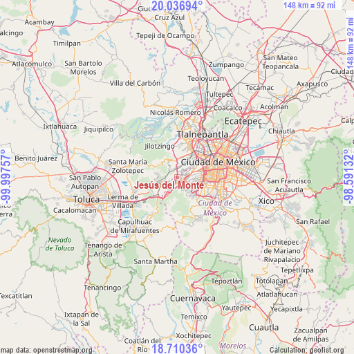
Jesús del Monte GPS coordinates[2]
19° 22' 30" North, 99° 17' 39.984" West
| Map corner | latitude | longitude |
|---|---|---|
| Upper-left | 20.03694°, | -99.99757° |
| Center: | 19.375°, | -99.29444° |
| Lower-right: | 18.71036°, | -98.59132° |
| Map W x H: | 147.5×147.5 km | = 91.7×91.7mi |
| max Lat: | 32.7° ⇑56.9% North |
| Jesús del Monte: | 19.375° |
| min Lat: | ⇓43.1% South 14.53588° |
| min Long | Jesús del Mont | max Long |
| -117.105° | -99.29444° | -86.73105° |
| W 45.9%⇐ | ⇒54.1% E |
Elevation
Elevation of Jesús del Monte is 2653 m = 8704 ft, and this is 1399.3 m = 4591 ft above average elevation for this country.
| Max E: |
3497 m = 11473 ft | 3.5% |
| Jesús del Monte | 2653 m 8704 ft | |
| Avg. | 1253.7 m = 4113 ft | |
Min E: |
-1 m = -3 ft | 96.5% |
See also: Mexico elevation on elevation.city.
Geographical zone
Jesús del Monte is located in North Torrid zone (between Equator and Tropic of Cancer). Distance of this Northern Tropic circle is 451.6 km =280.6 mi to North.| Distance of | km | miles | from Jesús del Monte |
|---|---|---|---|
| North Pole | 7852.8 | 4879.5 | to North |
| Arctic Circle | 5246.9 | 3260.3 | to North |
| Tropic Cancer | 451.6 | 280.6 | to North |
| Equator | 2154.3 | 1338.6 | to South |


Nearby cities:
15 places around Jesús del Monte: (largest is in red/bold)
• Arenal
4.3 km =2.7 mi,  350°
350°
• Barrio de San Ramón
3.8 km =2.4 mi,  267°
267°
• Col. Bosques de las Lomas
3 km =1.9 mi,  81°
81°
• Colonia La Venta
4.8 km =3 mi,  201°
201°
• Delegación Cuajimalpa de Morelos
0.7 km =0.4 mi,  149°
149°
• Dos Ríos
5.2 km =3.2 mi, 269°
• El Mirasol
4.8 km =3 mi,  234°
234°
• La Magdalena Chichicaspa
5.3 km =3.3 mi,  321°
321°
• Paraje Trejo (El Chaparral)
3.9 km =2.4 mi,  331°
331°
• Paraje el Mirador
4.4 km =2.7 mi,  308°
308°
• Paraje la Pera
5.3 km =3.3 mi,  276°
276°
• San Bartolomé Coatepec
3.1 km =1.9 mi, 323°
• San Jacinto
3.3 km =2.1 mi,  245°
245°
• Santiago Yancuitlalpan
1.5 km =0.9 mi, 313°
• Zacamulpa
4.4 km =2.7 mi,  241°
241°
Sources, notices
• [Note1] Compared only with cities in Mexico existing in our database
• [Src1] Map data: © OpenStreetMap contributors (CC-BY-SA)
• [Src2] Other city data from geonames.org with taken over terms of usage.
• [Src3] Geographical zone / Annual Mean Temperature by Robert A. Rohde @ Wikipedia
