Teotlaltzingo geodata
Teotlaltzingo (Puebla) is a populated place; located in Mexico in America/Mexico_City (GMT-6) time zone. With population of 6,166 people, there are 1514 cities with bigger population in this country. Compared to other cities in Mexico, 60.4% of cities are located further ↑North; 57.2% of cities are located further ←West and 90.7% of cities have lower elevation than Teotlaltzingo. Note1


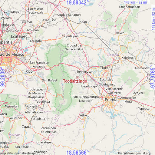
Teotlaltzingo GPS coordinates[2]
19° 13' 51.168" North, 98° 30' 2.772" West
| Map corner | latitude | longitude |
|---|---|---|
| Upper-left | 19.89342°, | -99.2039° |
| Center: | 19.23088°, | -98.50077° |
| Lower-right: | 18.56566°, | -97.79765° |
| Map W x H: | 147.6×147.6 km | = 91.7×91.7mi |
| max Lat: | 32.7° ⇑60.4% North |
| Teotlaltzingo: | 19.23088° |
| min Lat: | ⇓39.6% South 14.53588° |
| min Long | Teotlaltzingo | max Long |
| -117.105° | -98.50077° | -86.73105° |
| W 57.2%⇐ | ⇒42.8% E |
Elevation
Elevation of Teotlaltzingo is 2430 m = 7972 ft, and this is 1176.3 m = 3859 ft above average elevation for this country.
| Max E: |
3497 m = 11473 ft | 9.3% |
| Teotlaltzingo | 2430 m 7972 ft | |
| Avg. | 1253.7 m = 4113 ft | |
Min E: |
-1 m = -3 ft | 90.7% |
See also: Mexico elevation on elevation.city.
Geographical zone
Teotlaltzingo is located in North Torrid zone (between Equator and Tropic of Cancer). Distance of this Northern Tropic circle is 467.6 km =290.6 mi to North.| Distance of | km | miles | from Teotlaltzingo |
|---|---|---|---|
| North Pole | 7868.8 | 4889.4 | to North |
| Arctic Circle | 5262.9 | 3270.2 | to North |
| Tropic Cancer | 467.6 | 290.6 | to North |
| Equator | 2138.3 | 1328.7 | to South |


Nearby cities:
15 places around Teotlaltzingo: (largest is in red/bold)
• Analco de Ponciano Arriaga (Santa Cruz Analco)
3.7 km =2.3 mi,  0°
0°
• San Agustín Atzompa
3.5 km =2.2 mi,  202°
202°
• San Andrés Hueyacatitla
4.7 km =2.9 mi,  306°
306°
• San Antonio Tlatenco
6.4 km =4 mi,  179°
179°
• San Buenaventura Tecaltzingo
4.6 km =2.9 mi,  66°
66°
• San Francisco Tepeyecac
6.8 km =4.2 mi, 73°
• San Gregorio Aztotoacan
3.8 km =2.4 mi,  13°
13°
• San Juan Tetla
1.8 km =1.1 mi,  193°
193°
• San Juan Tuxco
6.1 km =3.8 mi,  58°
58°
• San Lorenzo Chiautzingo
4.6 km =2.9 mi,  130°
130°
• San Matías Atzala
3 km =1.9 mi,  41°
41°
• San Nicolás Zecalacoayan
3.8 km =2.4 mi,  159°
159°
• San Salvador el Verde
4.7 km =2.9 mi,  339°
339°
• San Simón Atzitzintla
4.5 km =2.8 mi, 35°
• Tlacotepec de José Manzo
4.9 km =3 mi,  20°
20°
Sources, notices
• [Note1] Compared only with cities in Mexico existing in our database
• [Src1] Map data: © OpenStreetMap contributors (CC-BY-SA)
• [Src2] Other city data from geonames.org with taken over terms of usage.
• [Src3] Geographical zone / Annual Mean Temperature by Robert A. Rohde @ Wikipedia
