Miramar geodata
Miramar (Tamaulipas) is a populated place; located in Mexico in America/Monterrey (GMT-6) time zone. With population of 118,614 people, there are 120 cities with bigger population in this country. Compared to other cities in Mexico, 86% of cities are located further ↓South; 64.8% of cities are located further ←West and 98.1% of cities have higher elevation than Miramar. Note1


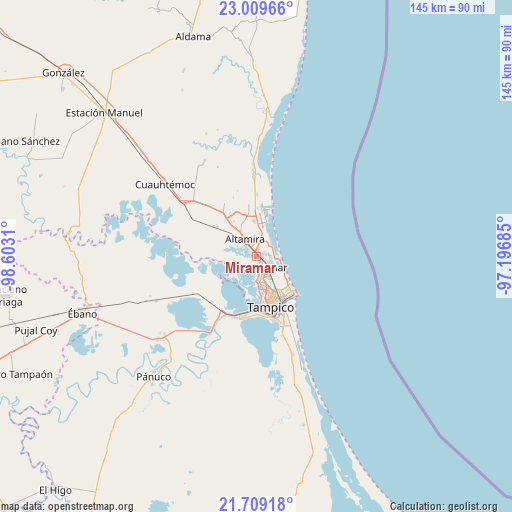
Miramar GPS coordinates[2]
22° 21' 39.384" North, 97° 53' 59.892" West
| Map corner | latitude | longitude |
|---|---|---|
| Upper-left | 23.00966°, | -98.6031° |
| Center: | 22.36094°, | -97.89997° |
| Lower-right: | 21.70918°, | -97.19685° |
| Map W x H: | 144.6×144.6 km | = 89.9×89.9mi |
| max Lat: | 32.7° ⇑14% North |
| Miramar: | 22.36094° |
| min Lat: | ⇓86% South 14.53588° |
| min Long | Miramar | max Long |
| -117.105° | -97.89997° | -86.73105° |
| W 64.8%⇐ | ⇒35.2% E |
Elevation
Elevation of Miramar is 8 m = 26 ft, and this is 1245.7 m = 4087 ft below average elevation for this country.
| Max E: |
3497 m = 11473 ft | 98.1% |
| Avg. | 1253.7 m = 4113 ft | |
| Miramar | 8 m = 26 ft | |
Min E: |
-1 m = -3 ft | 1.9% |
See also: Miramar elevation on elevation.city.
Geographical zone
Miramar is located in North Torrid zone (between Equator and Tropic of Cancer). Distance of this Northern Tropic circle is 119.6 km =74.3 mi to North.| Distance of | km | miles | from Miramar |
|---|---|---|---|
| North Pole | 7520.8 | 4673.2 | to North |
| Arctic Circle | 4914.9 | 3054 | to North |
| Tropic Cancer | 119.6 | 74.3 | to North |
| Equator | 2486.3 | 1544.9 | to South |


Nearby cities:
15 places around Miramar: (largest is in red/bold)
• Altamira
5.3 km =3.3 mi,  311°
311°
• Anahuac
18.2 km =11.3 mi,  165°
165°
• Carrillo Puerto
10.2 km =6.3 mi,  319°
319°
• Ciudad Madero
11.8 km =7.3 mi,  146°
146°
• Francisco Medrano
8.6 km =5.3 mi,  1°
1°
• La Colonia
14.8 km =9.2 mi, 305°
• La Pedrera
4.1 km =2.5 mi,  26°
26°
• Lomas del Real
17.7 km =11 mi, 0°
• Moralillo
15.1 km =9.4 mi,  184°
184°
• Nuevo Cereso Regional de Altamira
15.7 km =9.8 mi, 314°
• Primero de Mayo
17.2 km =10.7 mi, 151°
• Ricardo Flores Magón
10.1 km =6.3 mi,  355°
355°
• Tampico
8.7 km =5.4 mi,  164°
164°
• Tres de Mayo
13.6 km =8.5 mi,  292°
292°
• Unidos Avanzamos
11 km =6.8 mi, 317°
Sources, notices
• [Note1] Compared only with cities in Mexico existing in our database
• [Src1] Map data: © OpenStreetMap contributors (CC-BY-SA)
• [Src2] Other city data from geonames.org with taken over terms of usage.
• [Src3] Geographical zone / Annual Mean Temperature by Robert A. Rohde @ Wikipedia
