Nuevo Cereso Regional de Altamira geodata
Nuevo Cereso Regional de Altamira (Tamaulipas) is a populated place; located in Mexico in America/Monterrey (GMT-6) time zone. With population of 1,158 people, there are 7487 cities with bigger population in this country. Compared to other cities in Mexico, 86.6% of cities are located further ↓South; 63.5% of cities are located further ←West and 88.3% of cities have higher elevation than Nuevo Cereso Regional de Altamira. Note1
Current local time in Nuevo Cereso Regional de Altamira:
09:49 PM, TuesdayDifference from your time zone: hours


Nuevo Cereso Regional de Altamira GPS coordinates[2]
22° 27' 38.016" North, 98° 0' 29.988" West
| Map corner | latitude | longitude |
|---|---|---|
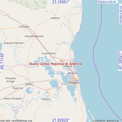
| Upper-left | 23.10881°, | -98.71146° |
| Center: | 22.46056°, | -98.00833° |
| Lower-right: | 21.80926°, | -97.30521° |
| Map W x H: | 144.5×144.5 km | = 89.8×89.8mi |
| max Lat: | 32.7° ⇑13.4% North |
| Nuevo Cereso Regional de Altamira: | 22.46056° |
| min Lat: | ⇓86.6% South 14.53588° |
| min Long | Nuevo Cereso Re | max Long |
| -117.105° | -98.00833° | -86.73105° |
| W 63.5%⇐ | ⇒36.5% E |
Elevation
Elevation of Nuevo Cereso Regional de Altamira is 29 m = 95 ft, and this is 1224.7 m = 4018 ft below average elevation for this country.
| Max E: |
3497 m = 11473 ft | 88.3% |
| Avg. | 1253.7 m = 4113 ft | |
| Nuevo Cereso Regional de Altamira | 29 m = 95 ft | |
Min E: |
-1 m = -3 ft | 11.7% |
See also: Mexico elevation on elevation.city.
Geographical zone
Nuevo Cereso Regional de Altamira is located in North Torrid zone (between Equator and Tropic of Cancer). Distance of this Northern Tropic circle is 108.5 km =67.4 mi to North.| Distance of | km | miles | from Nuevo Cereso Regional de Altamira |
|---|---|---|---|
| North Pole | 7509.7 | 4666.3 | to North |
| Arctic Circle | 4903.8 | 3047.1 | to North |
| Tropic Cancer | 108.5 | 67.4 | to North |
| Equator | 2497.4 | 1551.8 | to South |


Nearby cities:
15 places around Nuevo Cereso Regional de Altamira: (largest is in red/bold)
• Altamira
10.4 km =6.5 mi,  136°
136°
• Aquiles Serdán
15.8 km =9.8 mi,  42°
42°
• Benito Juárez
3.8 km =2.4 mi,  330°
330°
• Carrillo Puerto
5.6 km =3.5 mi,  125°
125°
• El Fuerte
8.3 km =5.2 mi,  243°
243°
• Esteros
13.8 km =8.6 mi,  298°
298°
• Francisco Medrano
11.6 km =7.2 mi,  102°
102°
• La Colonia
2.6 km =1.6 mi,  200°
200°
• La Pedrera
15 km =9.3 mi,  119°
119°
• Lomas del Real
13 km =8.1 mi,  59°
59°
• Maclovio Herrera
9.1 km =5.7 mi, 299°
• Miramar
15.7 km =9.8 mi, 134°
• Ricardo Flores Magón
10.4 km =6.5 mi, 95°
• Tres de Mayo
6.1 km =3.8 mi,  193°
193°
• Unidos Avanzamos
4.8 km =3 mi, 128°
Sources, notices
• [Note1] Compared only with cities in Mexico existing in our database
• [Src1] Map data: © OpenStreetMap contributors (CC-BY-SA)
• [Src2] Other city data from geonames.org with taken over terms of usage.
• [Src3] Geographical zone / Annual Mean Temperature by Robert A. Rohde @ Wikipedia
