La Nopalera geodata
La Nopalera (Morelos) is a populated place; located in Mexico in America/Mexico_City (GMT-6) time zone. With population of 768 people, there are 11396 cities with bigger population in this country. Compared to other cities in Mexico, 68.8% of cities are located further ↑North; 50.6% of cities are located further →East and 57% of cities have higher elevation than La Nopalera. Note1


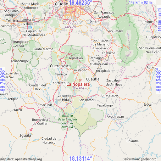
La Nopalera GPS coordinates[2]
18° 47' 53.016" North, 99° 3' 27" West
| Map corner | latitude | longitude |
|---|---|---|
| Upper-left | 19.46235°, | -99.76063° |
| Center: | 18.79806°, | -99.0575° |
| Lower-right: | 18.13114°, | -98.35438° |
| Map W x H: | 148×148 km | = 92×92mi |
| max Lat: | 32.7° ⇑68.8% North |
| La Nopalera: | 18.79806° |
| min Lat: | ⇓31.2% South 14.53588° |
| min Long | La Nopalera | max Long |
| -117.105° | -99.0575° | -86.73105° |
| W 49.4%⇐ | ⇒50.6% E |
Elevation
Elevation of La Nopalera is 1123 m = 3684 ft, and this is 130.7 m = 429 ft below average elevation for this country.
| Max E: |
3497 m = 11473 ft | 57% |
| Avg. | 1253.7 m = 4113 ft | |
| La Nopalera | 1123 m = 3684 ft | |
Min E: |
-1 m = -3 ft | 43% |
See also: Mexico elevation on elevation.city.
Geographical zone
La Nopalera is located in North Torrid zone (between Equator and Tropic of Cancer). Distance of this Northern Tropic circle is 515.8 km =320.5 mi to North.| Distance of | km | miles | from La Nopalera |
|---|---|---|---|
| North Pole | 7916.9 | 4919.3 | to North |
| Arctic Circle | 5311 | 3300.1 | to North |
| Tropic Cancer | 515.8 | 320.5 | to North |
| Equator | 2090.1 | 1298.7 | to South |


Nearby cities:
15 places around La Nopalera: (largest is in red/bold)
• 3 de Mayo
7.1 km =4.4 mi,  65°
65°
• Abelardo L. Rodríguez
10.2 km =6.3 mi,  131°
131°
• Anenecuilco
7.6 km =4.7 mi,  107°
107°
• Barranca Honda
5.6 km =3.5 mi,  293°
293°
• Ciudad Ayala
8.6 km =5.3 mi, 113°
• Colonia Ejidal Rafael Merino
9.8 km =6.1 mi, 128°
• El Caudillo del Sur
8.1 km =5 mi,  334°
334°
• Ex-Hacienda el Hospital
7.4 km =4.6 mi,  60°
60°
• Los Arcos
10.5 km =6.5 mi,  19°
19°
• Olintepec
9.8 km =6.1 mi, 130°
• Puxtla
8 km =5 mi,  80°
80°
• San Isidro
4.7 km =2.9 mi,  304°
304°
• San Pedro Apatlaco
10.3 km =6.4 mi,  93°
93°
• Ticumán
8 km =5 mi,  235°
235°
• Yautepec
9.4 km =5.8 mi,  353°
353°
Sources, notices
• [Note1] Compared only with cities in Mexico existing in our database
• [Src1] Map data: © OpenStreetMap contributors (CC-BY-SA)
• [Src2] Other city data from geonames.org with taken over terms of usage.
• [Src3] Geographical zone / Annual Mean Temperature by Robert A. Rohde @ Wikipedia
