Puxtla geodata
Puxtla (Morelos) is a populated place; located in Mexico in America/Mexico_City (GMT-6) time zone. With population of 1,476 people, there are 5851 cities with bigger population in this country. Compared to other cities in Mexico, 68.6% of cities are located further ↑North; 50.5% of cities are located further ←West and 53.3% of cities have higher elevation than Puxtla. Note1


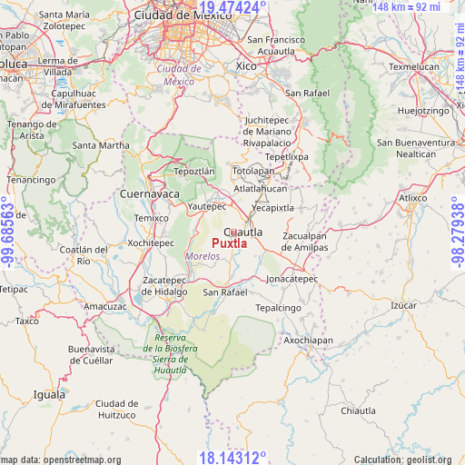
Puxtla GPS coordinates[2]
18° 48' 36" North, 98° 58' 57" West
| Map corner | latitude | longitude |
|---|---|---|
| Upper-left | 19.47424°, | -99.68563° |
| Center: | 18.81°, | -98.9825° |
| Lower-right: | 18.14312°, | -98.27938° |
| Map W x H: | 148×148 km | = 92×92mi |
| max Lat: | 32.7° ⇑68.6% North |
| Puxtla: | 18.81° |
| min Lat: | ⇓31.4% South 14.53588° |
| min Long | Puxtla | max Long |
| -117.105° | -98.9825° | -86.73105° |
| W 50.5%⇐ | ⇒49.5% E |
Elevation
Elevation of Puxtla is 1275 m = 4183 ft, and this is 21.3 m = 70 ft above average elevation for this country.
| Max E: |
3497 m = 11473 ft | 53.3% |
| Puxtla | 1275 m 4183 ft | |
| Avg. | 1253.7 m = 4113 ft | |
Min E: |
-1 m = -3 ft | 46.7% |
See also: Mexico elevation on elevation.city.
Geographical zone
Puxtla is located in North Torrid zone (between Equator and Tropic of Cancer). Distance of this Northern Tropic circle is 514.4 km =319.6 mi to North.| Distance of | km | miles | from Puxtla |
|---|---|---|---|
| North Pole | 7915.6 | 4918.5 | to North |
| Arctic Circle | 5309.7 | 3299.3 | to North |
| Tropic Cancer | 514.4 | 319.6 | to North |
| Equator | 2091.5 | 1299.6 | to South |


Nearby cities:
15 places around Puxtla: (largest is in red/bold)
• 3 de Mayo
2.1 km =1.3 mi,  317°
317°
• Anenecuilco
3.7 km =2.3 mi,  190°
190°
• Calderón
5.4 km =3.4 mi,  4°
4°
• Ciudad Ayala
4.8 km =3 mi,  179°
179°
• Colonia las Arboledas
5.3 km =3.3 mi,  121°
121°
• Cuautla
5 km =3.1 mi,  89°
89°
• Ex-Hacienda el Hospital
2.8 km =1.7 mi,  327°
327°
• Juan Morales
6.4 km =4 mi, 88°
• Loma Bonita
7 km =4.3 mi, 86°
• Narciso Mendoza
7.3 km =4.5 mi,  10°
10°
• Niños Héroes
5.7 km =3.5 mi,  150°
150°
• Peña Flores (Palo Verde)
6.5 km =4 mi, 13°
• Reforma
6 km =3.7 mi, 121°
• San Pedro Apatlaco
3 km =1.9 mi,  128°
128°
• Tierra Larga (Campo Nuevo)
7.1 km =4.4 mi,  30°
30°
Sources, notices
• [Note1] Compared only with cities in Mexico existing in our database
• [Src1] Map data: © OpenStreetMap contributors (CC-BY-SA)
• [Src2] Other city data from geonames.org with taken over terms of usage.
• [Src3] Geographical zone / Annual Mean Temperature by Robert A. Rohde @ Wikipedia
