Ignacio López Rayón geodata
Ignacio López Rayón (Chiapas) is a populated place; located in Mexico in America/Mexico_City (GMT-6) time zone. With population of 1,573 people, there are 5492 cities with bigger population in this country. Compared to other cities in Mexico, 100% of cities are located further ↑North; 94.2% of cities are located further ←West and 92.5% of cities have higher elevation than Ignacio López Rayón. Note1


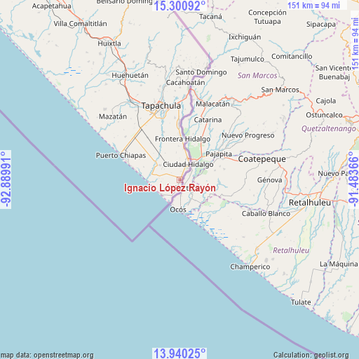
Ignacio López Rayón GPS coordinates[2]
14° 37' 17.904" North, 92° 11' 12.408" West
| Map corner | latitude | longitude |
|---|---|---|
| Upper-left | 15.30092°, | -92.88991° |
| Center: | 14.62164°, | -92.18678° |
| Lower-right: | 13.94025°, | -91.48366° |
| Map W x H: | 151.3×151.3 km | = 94×94mi |
| max Lat: | 32.7° ⇑100% North |
| Ignacio López Rayón: | 14.62164° |
| min Lat: | ⇓0% South 14.53588° |
| min Long | Ignacio López | max Long |
| -117.105° | -92.18678° | -86.73105° |
| W 94.2%⇐ | ⇒5.8% E |
Elevation
Elevation of Ignacio López Rayón is 18 m = 59 ft, and this is 1235.7 m = 4054 ft below average elevation for this country.
| Max E: |
3497 m = 11473 ft | 92.5% |
| Avg. | 1253.7 m = 4113 ft | |
| Ignacio López Rayón | 18 m = 59 ft | |
Min E: |
-1 m = -3 ft | 7.5% |
See also: Mexico elevation on elevation.city.
Geographical zone
Ignacio López Rayón is located in North Torrid zone (between Equator and Tropic of Cancer). Distance of this Northern Tropic circle is 980.1 km =609 mi to North.| Distance of | km | miles | from Ignacio López Rayón |
|---|---|---|---|
| North Pole | 8381.3 | 5207.9 | to North |
| Arctic Circle | 5775.4 | 3588.7 | to North |
| Tropic Cancer | 980.1 | 609 | to North |
| Equator | 1625.8 | 1010.2 | to South |


Nearby cities:
15 places around Ignacio López Rayón: (largest is in red/bold)
• Barra de Cahoacán (El Chical)
12.6 km =7.8 mi,  279°
279°
• Benito Juárez
8.7 km =5.4 mi, 281°
• Brisas Barra de Suchiate
10.3 km =6.4 mi,  202°
202°
• Ciudad Hidalgo
7.6 km =4.7 mi,  29°
29°
• Cuauhtémoc
5 km =3.1 mi,  240°
240°
• Dorado Nuevo
6.4 km =4 mi,  336°
336°
• El Campito
6.2 km =3.9 mi,  11°
11°
• El Gancho
10 km =6.2 mi,  228°
228°
• General Manuel Ávila Camacho
5.8 km =3.6 mi,  294°
294°
• Ignacio Zaragoza
13.3 km =8.3 mi, 7°
• Jesús Carranza
2.4 km =1.5 mi, 31°
• La Libertad
3.4 km =2.1 mi,  191°
191°
• Miguel Alemán
7.6 km =4.7 mi, 204°
• Poblado Francisco I. Madero
14.2 km =8.8 mi,  354°
354°
• Tierra y Libertad
9.6 km =6 mi, 228°
Sources, notices
• [Note1] Compared only with cities in Mexico existing in our database
• [Src1] Map data: © OpenStreetMap contributors (CC-BY-SA)
• [Src2] Other city data from geonames.org with taken over terms of usage.
• [Src3] Geographical zone / Annual Mean Temperature by Robert A. Rohde @ Wikipedia
