General Manuel Ávila Camacho geodata
General Manuel Ávila Camacho (Chiapas) is a populated place; located in Mexico in America/Mexico_City (GMT-6) time zone. With population of 510 people, there are 16480 cities with bigger population in this country. Compared to other cities in Mexico, 99.9% of cities are located further ↑North; 93.9% of cities are located further ←West and 95.1% of cities have higher elevation than General Manuel Ávila Camacho. Note1
Current local time in General Manuel Ávila Camacho:
06:53 AM, WednesdayDifference from your time zone: hours


General Manuel Ávila Camacho GPS coordinates[2]
14° 38' 34.008" North, 92° 14' 8.016" West
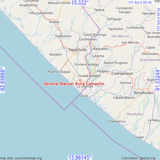
| Map corner | latitude | longitude |
|---|---|---|
| Upper-left | 15.322°, | -92.93869° |
| Center: | 14.64278°, | -92.23556° |
| Lower-right: | 13.96145°, | -91.53244° |
| Map W x H: | 151.3×151.3 km | = 94×94mi |
| max Lat: | 32.7° ⇑99.9% North |
| General Manuel Ávila Camacho: | 14.64278° |
| min Lat: | ⇓0.1% South 14.53588° |
| min Long | General Manuel | max Long |
| -117.105° | -92.23556° | -86.73105° |
| W 93.9%⇐ | ⇒6.1% E |
Elevation
Elevation of General Manuel Ávila Camacho is 13 m = 43 ft, and this is 1240.7 m = 4071 ft below average elevation for this country.
| Max E: |
3497 m = 11473 ft | 95.1% |
| Avg. | 1253.7 m = 4113 ft | |
| General Manuel Ávila Camacho | 13 m = 43 ft | |
Min E: |
-1 m = -3 ft | 4.9% |
See also: Mexico elevation on elevation.city.
Geographical zone
General Manuel Ávila Camacho is located in North Torrid zone (between Equator and Tropic of Cancer). Distance of this Northern Tropic circle is 977.8 km =607.6 mi to North.| Distance of | km | miles | from General Manuel Ávila Camacho |
|---|---|---|---|
| North Pole | 8378.9 | 5206.4 | to North |
| Arctic Circle | 5773 | 3587.2 | to North |
| Tropic Cancer | 977.8 | 607.6 | to North |
| Equator | 1628.1 | 1011.7 | to South |


Nearby cities:
15 places around General Manuel Ávila Camacho: (largest is in red/bold)
• Barra de Cahoacán (El Chical)
7.1 km =4.4 mi,  268°
268°
• Benito Juárez
3.3 km =2.1 mi,  260°
260°
• Brisas Barra de Suchiate
11.9 km =7.4 mi,  174°
174°
• Ciudad Hidalgo
9.9 km =6.2 mi,  64°
64°
• Cuauhtémoc
4.9 km =3 mi, 169°
• Dorado Nuevo
4.4 km =2.7 mi,  37°
37°
• El Campito
7.5 km =4.7 mi, 60°
• El Gancho
9.2 km =5.7 mi,  194°
194°
• Ignacio López Rayón
5.8 km =3.6 mi,  114°
114°
• Ignacio Zaragoza
12.9 km =8 mi,  32°
32°
• Jesús Carranza
6.5 km =4 mi,  92°
92°
• La Libertad
7.3 km =4.5 mi,  141°
141°
• Miguel Alemán
9.5 km =5.9 mi, 167°
• Poblado Francisco I. Madero
12.5 km =7.8 mi,  18°
18°
• Tierra y Libertad
8.9 km =5.5 mi, 192°
Sources, notices
• [Note1] Compared only with cities in Mexico existing in our database
• [Src1] Map data: © OpenStreetMap contributors (CC-BY-SA)
• [Src2] Other city data from geonames.org with taken over terms of usage.
• [Src3] Geographical zone / Annual Mean Temperature by Robert A. Rohde @ Wikipedia
