El Arenal geodata
El Arenal (Chiapas) is a populated place; located in Mexico in America/Mexico_City (GMT-6) time zone. With population of 1,157 people, there are 7495 cities with bigger population in this country. Compared to other cities in Mexico, 99% of cities are located further ↑North; 90.5% of cities are located further ←West and 96.3% of cities have higher elevation than El Arenal. Note1


El Arenal GPS coordinates[2]
15° 10' 21.828" North, 92° 41' 57.228" West
| Map corner | latitude | longitude |
|---|---|---|
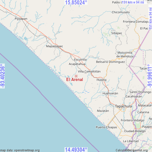
| Upper-left | 15.85024°, | -93.40236° |
| Center: | 15.17273°, | -92.69923° |
| Lower-right: | 14.49304°, | -91.99611° |
| Map W x H: | 150.9×150.9 km | = 93.8×93.8mi |
| max Lat: | 32.7° ⇑99% North |
| El Arenal: | 15.17273° |
| min Lat: | ⇓1% South 14.53588° |
| min Long | El Arenal | max Long |
| -117.105° | -92.69923° | -86.73105° |
| W 90.5%⇐ | ⇒9.5% E |
Elevation
Elevation of El Arenal is 11 m = 36 ft, and this is 1242.7 m = 4077 ft below average elevation for this country.
| Max E: |
3497 m = 11473 ft | 96.3% |
| Avg. | 1253.7 m = 4113 ft | |
| El Arenal | 11 m = 36 ft | |
Min E: |
-1 m = -3 ft | 3.7% |
See also: Mexico elevation on elevation.city.
Geographical zone
El Arenal is located in North Torrid zone (between Equator and Tropic of Cancer). Distance of this Northern Tropic circle is 918.9 km =571 mi to North.| Distance of | km | miles | from El Arenal |
|---|---|---|---|
| North Pole | 8320 | 5169.8 | to North |
| Arctic Circle | 5714.1 | 3550.6 | to North |
| Tropic Cancer | 918.9 | 571 | to North |
| Equator | 1687 | 1048.3 | to South |


Nearby cities:
15 places around El Arenal: (largest is in red/bold)
• Acapetahua
12.2 km =7.6 mi,  4°
4°
• Barrio Nuevo
8 km =5 mi,  5°
5°
• Cantón Santa Cruz la Unión
11.3 km =7 mi,  83°
83°
• Cantón el Progreso
6.3 km =3.9 mi,  121°
121°
• Cantón las Brisas
8.2 km =5.1 mi,  109°
109°
• El Madronal
12.3 km =7.6 mi,  356°
356°
• Emiliano Zapata
14.1 km =8.8 mi, 108°
• Hidalgo
7.5 km =4.7 mi,  98°
98°
• Las Cruces
12.4 km =7.7 mi,  344°
344°
• Luis Espinoza
2.1 km =1.3 mi,  23°
23°
• Mariano Matamoros
10.2 km =6.3 mi,  334°
334°
• Río Arriba Salvación
3 km =1.9 mi,  184°
184°
• Teziutlán
5.7 km =3.5 mi,  65°
65°
• Villa Comaltitlán
13.9 km =8.6 mi, 70°
• Zacualpa
7.8 km =4.8 mi,  93°
93°
Sources, notices
• [Note1] Compared only with cities in Mexico existing in our database
• [Src1] Map data: © OpenStreetMap contributors (CC-BY-SA)
• [Src2] Other city data from geonames.org with taken over terms of usage.
• [Src3] Geographical zone / Annual Mean Temperature by Robert A. Rohde @ Wikipedia
