Villa Comaltitlán geodata
Villa Comaltitlán (Chiapas) is a seat of a second-order administrative division; located in Mexico in America/Mexico_City (GMT-6) time zone. With population of 7,201 people, there are 1289 cities with bigger population in this country. Compared to other cities in Mexico, 99% of cities are located further ↑North; 91.3% of cities are located further ←West and 86.5% of cities have higher elevation than Villa Comaltitlán. Note1


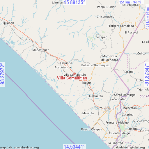
Villa Comaltitlán GPS coordinates[2]
15° 12' 50.292" North, 92° 34' 35.724" West
| Map corner | latitude | longitude |
|---|---|---|
| Upper-left | 15.89135°, | -93.27972° |
| Center: | 15.21397°, | -92.57659° |
| Lower-right: | 14.53441°, | -91.87347° |
| Map W x H: | 150.9×150.9 km | = 93.8×93.8mi |
| max Lat: | 32.7° ⇑99% North |
| Villa Comaltitlán: | 15.21397° |
| min Lat: | ⇓1% South 14.53588° |
| min Long | Villa Comaltitl | max Long |
| -117.105° | -92.57659° | -86.73105° |
| W 91.3%⇐ | ⇒8.7% E |
Elevation
Elevation of Villa Comaltitlán is 36 m = 118 ft, and this is 1217.7 m = 3995 ft below average elevation for this country.
| Max E: |
3497 m = 11473 ft | 86.5% |
| Avg. | 1253.7 m = 4113 ft | |
| Villa Comaltitlán | 36 m = 118 ft | |
Min E: |
-1 m = -3 ft | 13.5% |
See also: Mexico elevation on elevation.city.
Geographical zone
Villa Comaltitlán is located in North Torrid zone (between Equator and Tropic of Cancer). Distance of this Northern Tropic circle is 914.3 km =568.1 mi to North.| Distance of | km | miles | from Villa Comaltitlán |
|---|---|---|---|
| North Pole | 8315.4 | 5166.9 | to North |
| Arctic Circle | 5709.5 | 3547.7 | to North |
| Tropic Cancer | 914.3 | 568.1 | to North |
| Equator | 1691.6 | 1051.1 | to South |


Nearby cities:
15 places around Villa Comaltitlán: (largest is in red/bold)
• Aquiles Serdán
12.4 km =7.7 mi,  119°
119°
• Cantón Santa Cruz la Unión
3.8 km =2.4 mi,  211°
211°
• Cantón el Progreso
11.1 km =6.9 mi,  224°
224°
• Cantón las Brisas
9.1 km =5.7 mi, 216°
• Efraín A. Gutiérrez
12.3 km =7.6 mi,  168°
168°
• Emiliano Zapata
9.1 km =5.7 mi,  178°
178°
• Hidalgo
8.1 km =5 mi,  225°
225°
• Luis Espinoza
12.6 km =7.8 mi,  257°
257°
• Lázaro Cárdenas
5.2 km =3.2 mi,  150°
150°
• Monte Flor Arriba
11.9 km =7.4 mi,  2°
2°
• Nuevo Brasil
5 km =3.1 mi,  111°
111°
• San Felipe Tizapa
7.9 km =4.9 mi,  330°
330°
• Teziutlán
8.3 km =5.2 mi,  254°
254°
• Vicente Guerrero
5.8 km =3.6 mi,  23°
23°
• Zacualpa
7.4 km =4.6 mi, 226°
Sources, notices
• [Note1] Compared only with cities in Mexico existing in our database
• [Src1] Map data: © OpenStreetMap contributors (CC-BY-SA)
• [Src2] Other city data from geonames.org with taken over terms of usage.
• [Src3] Geographical zone / Annual Mean Temperature by Robert A. Rohde @ Wikipedia
