Efraín A. Gutiérrez geodata
Efraín A. Gutiérrez (Chiapas) is a populated place; located in Mexico in America/Mexico_City (GMT-6) time zone. With population of 669 people, there are 12968 cities with bigger population in this country. Compared to other cities in Mexico, 99.8% of cities are located further ↑North; 92% of cities are located further ←West and 96.3% of cities have higher elevation than Efraín A. Gutiérrez. Note1


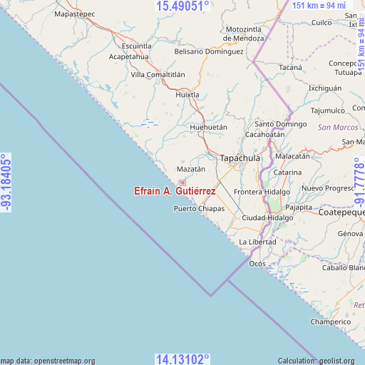
Efraín A. Gutiérrez GPS coordinates[2]
14° 48' 42.588" North, 92° 28' 51.312" West
| Map corner | latitude | longitude |
|---|---|---|
| Upper-left | 15.49051°, | -93.18405° |
| Center: | 14.81183°, | -92.48092° |
| Lower-right: | 14.13102°, | -91.7778° |
| Map W x H: | 151.2×151.2 km | = 94×94mi |
| max Lat: | 32.7° ⇑99.8% North |
| Efraín A. Gutiérrez: | 14.81183° |
| min Lat: | ⇓0.2% South 14.53588° |
| min Long | Efraín A. Guti | max Long |
| -117.105° | -92.48092° | -86.73105° |
| W 92%⇐ | ⇒8% E |
Elevation
Elevation of Efraín A. Gutiérrez is 11 m = 36 ft, and this is 1242.7 m = 4077 ft below average elevation for this country.
| Max E: |
3497 m = 11473 ft | 96.3% |
| Avg. | 1253.7 m = 4113 ft | |
| Efraín A. Gutiérrez | 11 m = 36 ft | |
Min E: |
-1 m = -3 ft | 3.7% |
See also: Mexico elevation on elevation.city.
Geographical zone
Efraín A. Gutiérrez is located in North Torrid zone (between Equator and Tropic of Cancer). Distance of this Northern Tropic circle is 959 km =595.9 mi to North.| Distance of | km | miles | from Efraín A. Gutiérrez |
|---|---|---|---|
| North Pole | 8360.1 | 5194.7 | to North |
| Arctic Circle | 5754.3 | 3575.6 | to North |
| Tropic Cancer | 959 | 595.9 | to North |
| Equator | 1646.9 | 1023.3 | to South |


Nearby cities:
15 places around Efraín A. Gutiérrez: (largest is in red/bold)
• Adolfo Ruiz Cortines
5.4 km =3.4 mi,  345°
345°
• Buenos Aires
8.7 km =5.4 mi,  359°
359°
• Cuatro Caminos
9.6 km =6 mi,  52°
52°
• El Aguacate
6.6 km =4.1 mi,  59°
59°
• El Encanto
11.8 km =7.3 mi,  139°
139°
• Francisco I. Madero (La Bolsa de la Botella)
11.9 km =7.4 mi,  66°
66°
• Guanacastal 1ra. Sección
2.8 km =1.7 mi,  26°
26°
• La Victoria
1.9 km =1.2 mi,  297°
297°
• Leoncillos
9.4 km =5.8 mi,  121°
121°
• Marte R. Gómez
13.4 km =8.3 mi,  17°
17°
• Mazatán
6.6 km =4.1 mi, 29°
• Puerto Madero
12 km =7.5 mi,  147°
147°
• San Cristóbal Buenavista
11.4 km =7.1 mi,  96°
96°
• San José de los Llanos
8.8 km =5.5 mi, 19°
• Tinajas 3ra. Sección
14.1 km =8.8 mi,  110°
110°
Sources, notices
• [Note1] Compared only with cities in Mexico existing in our database
• [Src1] Map data: © OpenStreetMap contributors (CC-BY-SA)
• [Src2] Other city data from geonames.org with taken over terms of usage.
• [Src3] Geographical zone / Annual Mean Temperature by Robert A. Rohde @ Wikipedia
