Cuernavaca geodata
Cuernavaca (Morelos) is a seat of a first-order administrative division; located in Mexico in America/Mexico_City (GMT-6) time zone. With population of 338,650 people, there are 60 cities with bigger population in this country. Compared to other cities in Mexico, 66.4% of cities are located further ↑North; 53.3% of cities are located further →East and 52.9% of cities have lower elevation than Cuernavaca. Note1


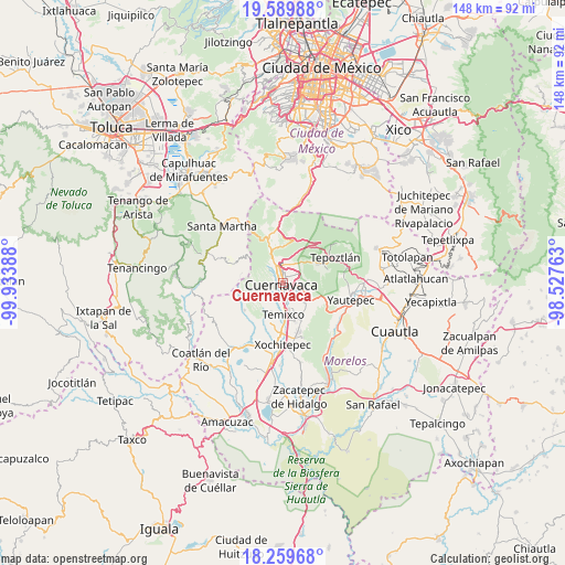
Cuernavaca GPS coordinates[2]
18° 55' 33.96" North, 99° 13' 50.7" West
| Map corner | latitude | longitude |
|---|---|---|
| Upper-left | 19.58988°, | -99.93388° |
| Center: | 18.9261°, | -99.23075° |
| Lower-right: | 18.25968°, | -98.52763° |
| Map W x H: | 147.9×147.9 km | = 91.9×91.9mi |
| max Lat: | 32.7° ⇑66.4% North |
| Cuernavaca: | 18.9261° |
| min Lat: | ⇓33.6% South 14.53588° |
| min Long | Cuernavaca | max Long |
| -117.105° | -99.23075° | -86.73105° |
| W 46.7%⇐ | ⇒53.3% E |
Elevation
Elevation of Cuernavaca is 1540 m = 5052 ft, and this is 286.3 m = 939 ft above average elevation for this country.
| Max E: |
3497 m = 11473 ft | 47.1% |
| Cuernavaca | 1540 m 5052 ft | |
| Avg. | 1253.7 m = 4113 ft | |
Min E: |
-1 m = -3 ft | 52.9% |
See also: Cuernavaca elevation on elevation.city.
Geographical zone
Cuernavaca is located in North Torrid zone (between Equator and Tropic of Cancer). Distance of this Northern Tropic circle is 501.5 km =311.6 mi to North.| Distance of | km | miles | from Cuernavaca |
|---|---|---|---|
| North Pole | 7902.7 | 4910.5 | to North |
| Arctic Circle | 5296.8 | 3291.3 | to North |
| Tropic Cancer | 501.5 | 311.6 | to North |
| Equator | 2104.4 | 1307.6 | to South |


Nearby cities:
15 places around Cuernavaca: (largest is in red/bold)
• Cerritos de García
6.3 km =3.9 mi,  52°
52°
• Colonia Alarcón
6.3 km =3.9 mi,  22°
22°
• Colonia Milpillas
5.2 km =3.2 mi,  64°
64°
• Colonia Santa Úrsula
6.3 km =3.9 mi,  228°
228°
• Colonia Unidad Deportiva
5.6 km =3.5 mi, 55°
• Colonia los Cerritos
5.1 km =3.2 mi, 52°
• Fraccionamiento Lomas de Ahuatlán
4.2 km =2.6 mi,  318°
318°
• Fraccionamiento Universo
6.1 km =3.8 mi, 49°
• Jiutepec
7.5 km =4.7 mi,  131°
131°
• La Cañada
7.2 km =4.5 mi,  41°
41°
• La Unión
3.9 km =2.4 mi,  210°
210°
• Loma Bonita
5.8 km =3.6 mi,  84°
84°
• Lomas de Ahuatepec
6.6 km =4.1 mi, 40°
• Tetecolala
7.2 km =4.5 mi,  93°
93°
• Tres de Mayo
6.8 km =4.2 mi,  159°
159°
Sources, notices
• [Note1] Compared only with cities in Mexico existing in our database
• [Src1] Map data: © OpenStreetMap contributors (CC-BY-SA)
• [Src2] Other city data from geonames.org with taken over terms of usage.
• [Src3] Geographical zone / Annual Mean Temperature by Robert A. Rohde @ Wikipedia
