Lomas de Ahuatepec geodata
Lomas de Ahuatepec (Morelos) is a populated place; located in Mexico in America/Mexico_City (GMT-6) time zone. With population of 1,040 people, there are 8386 cities with bigger population in this country. Compared to other cities in Mexico, 65.3% of cities are located further ↑North; 52.6% of cities are located further →East and 60.7% of cities have lower elevation than Lomas de Ahuatepec. Note1


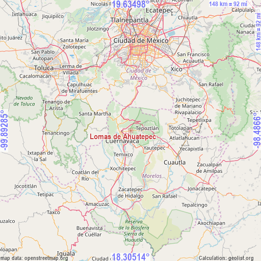
Lomas de Ahuatepec GPS coordinates[2]
18° 58' 17.004" North, 99° 11' 22.992" West
| Map corner | latitude | longitude |
|---|---|---|
| Upper-left | 19.63498°, | -99.89285° |
| Center: | 18.97139°, | -99.18972° |
| Lower-right: | 18.30514°, | -98.4866° |
| Map W x H: | 147.9×147.9 km | = 91.9×91.9mi |
| max Lat: | 32.7° ⇑65.3% North |
| Lomas de Ahuatepec: | 18.97139° |
| min Lat: | ⇓34.7% South 14.53588° |
| min Long | Lomas de Ahuate | max Long |
| -117.105° | -99.18972° | -86.73105° |
| W 47.4%⇐ | ⇒52.6% E |
Elevation
Elevation of Lomas de Ahuatepec is 1739 m = 5705 ft, and this is 485.3 m = 1592 ft above average elevation for this country.
| Max E: |
3497 m = 11473 ft | 39.3% |
| Lomas de Ahuatepec | 1739 m 5705 ft | |
| Avg. | 1253.7 m = 4113 ft | |
Min E: |
-1 m = -3 ft | 60.7% |
See also: Mexico elevation on elevation.city.
Geographical zone
Lomas de Ahuatepec is located in North Torrid zone (between Equator and Tropic of Cancer). Distance of this Northern Tropic circle is 496.5 km =308.5 mi to North.| Distance of | km | miles | from Lomas de Ahuatepec |
|---|---|---|---|
| North Pole | 7897.6 | 4907.3 | to North |
| Arctic Circle | 5291.8 | 3288.2 | to North |
| Tropic Cancer | 496.5 | 308.5 | to North |
| Equator | 2109.4 | 1310.7 | to South |


Nearby cities:
15 places around Lomas de Ahuatepec: (largest is in red/bold)
• Cerritos de García
1.3 km =0.8 mi,  149°
149°
• Coajomulco
7.1 km =4.4 mi,  347°
347°
• Colonia Alarcón
2 km =1.2 mi,  293°
293°
• Colonia Loma Esmeralda
7.5 km =4.7 mi, 148°
• Colonia Milpillas
2.8 km =1.7 mi,  172°
172°
• Colonia Unidad Deportiva
1.9 km =1.2 mi, 170°
• Colonia los Cerritos
2 km =1.2 mi,  188°
188°
• Cuernavaca
6.6 km =4.1 mi,  220°
220°
• Fraccionamiento Lomas de Ahuatlán
7.3 km =4.5 mi,  255°
255°
• Fraccionamiento Universo
1.1 km =0.7 mi,  162°
162°
• La Cañada
0.6 km =0.4 mi,  47°
47°
• Loma Bonita
4.7 km =2.9 mi, 161°
• Santa Catarina
5.2 km =3.2 mi,  92°
92°
• Tetecolala
6.1 km =3.8 mi, 152°
• Villa Santiago
1 km =0.6 mi,  26°
26°
Sources, notices
• [Note1] Compared only with cities in Mexico existing in our database
• [Src1] Map data: © OpenStreetMap contributors (CC-BY-SA)
• [Src2] Other city data from geonames.org with taken over terms of usage.
• [Src3] Geographical zone / Annual Mean Temperature by Robert A. Rohde @ Wikipedia
