Chiltepec geodata
Chiltepec (Tabasco) is a populated place; located in Mexico in America/Mexico_City (GMT-6) time zone. With population of 752 people, there are 11651 cities with bigger population in this country. Compared to other cities in Mexico, 73.4% of cities are located further ↑North; 88.2% of cities are located further ←West and 99.3% of cities have higher elevation than Chiltepec. Note1


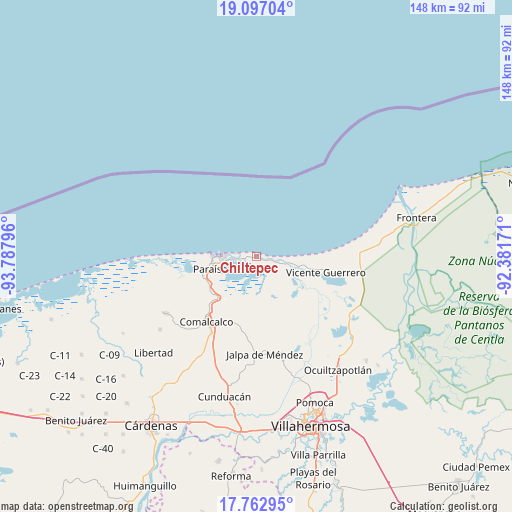
Chiltepec GPS coordinates[2]
18° 25' 52.644" North, 93° 5' 5.388" West
| Map corner | latitude | longitude |
|---|---|---|
| Upper-left | 19.09704°, | -93.78796° |
| Center: | 18.43129°, | -93.08483° |
| Lower-right: | 17.76295°, | -92.38171° |
| Map W x H: | 148.3×148.3 km | = 92.1×92.1mi |
| max Lat: | 32.7° ⇑73.4% North |
| Chiltepec: | 18.43129° |
| min Lat: | ⇓26.6% South 14.53588° |
| min Long | Chiltepec | max Long |
| -117.105° | -93.08483° | -86.73105° |
| W 88.2%⇐ | ⇒11.8% E |
Elevation
Elevation of Chiltepec is 5 m = 16 ft, and this is 1248.7 m = 4097 ft below average elevation for this country.
| Max E: |
3497 m = 11473 ft | 99.3% |
| Avg. | 1253.7 m = 4113 ft | |
| Chiltepec | 5 m = 16 ft | |
Min E: |
-1 m = -3 ft | 0.7% |
See also: Mexico elevation on elevation.city.
Geographical zone
Chiltepec is located in North Torrid zone (between Equator and Tropic of Cancer). Distance of this Northern Tropic circle is 556.6 km =345.9 mi to North.| Distance of | km | miles | from Chiltepec |
|---|---|---|---|
| North Pole | 7957.7 | 4944.7 | to North |
| Arctic Circle | 5351.8 | 3325.5 | to North |
| Tropic Cancer | 556.6 | 345.9 | to North |
| Equator | 2049.4 | 1273.4 | to South |


Nearby cities:
15 places around Chiltepec: (largest is in red/bold)
• Adolfo López Mateos
14.1 km =8.8 mi,  97°
97°
• Aquiles Serdán
7.8 km =4.8 mi, 104°
• Carlos A. Madrazo
11.6 km =7.2 mi,  93°
93°
• El Bellote (Miguel de la Madrid)
7 km =4.3 mi,  264°
264°
• El Escribano
14.6 km =9.1 mi, 260°
• Ignacio Zaragoza
13.6 km =8.5 mi, 104°
• Jalapita
9.7 km =6 mi, 100°
• Lázaro Cárdenas
13.2 km =8.2 mi, 99°
• Nuevo Torno Largo
8.4 km =5.2 mi,  270°
270°
• Oriente 2da. Sección (Palma Huaca)
15.5 km =9.6 mi,  223°
223°
• Paraiso
14 km =8.7 mi, 256°
• Puerto Ceiba
10.2 km =6.3 mi, 257°
• Pénjamo
0.9 km =0.6 mi,  291°
291°
• Quintín Arauz
15.6 km =9.7 mi,  245°
245°
• San Juan
11.2 km =7 mi, 102°
Sources, notices
• [Note1] Compared only with cities in Mexico existing in our database
• [Src1] Map data: © OpenStreetMap contributors (CC-BY-SA)
• [Src2] Other city data from geonames.org with taken over terms of usage.
• [Src3] Geographical zone / Annual Mean Temperature by Robert A. Rohde @ Wikipedia
