El Bellote (Miguel de la Madrid) geodata
El Bellote (Miguel de la Madrid) (Tabasco) is a populated place; located in Mexico in America/Merida (GMT-6) time zone. With population of 1,113 people, there are 7804 cities with bigger population in this country. Compared to other cities in Mexico, 73.4% of cities are located further ↑North; 87.8% of cities are located further ←West and 100% of cities have higher elevation than El Bellote (Miguel de la Madrid). Note1
Current local time in El Bellote (Miguel de la Madrid):
11:21 AM, MondayDifference from your time zone: hours


El Bellote (Miguel de la Madrid) GPS coordinates[2]
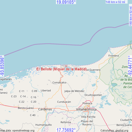
18° 25' 31.008" North, 93° 9' 2.988" West
| Map corner | latitude | longitude |
|---|---|---|
| Upper-left | 19.09105°, | -93.85396° |
| Center: | 18.42528°, | -93.15083° |
| Lower-right: | 17.75692°, | -92.44771° |
| Map W x H: | 148.3×148.3 km | = 92.1×92.1mi |
| max Lat: | 32.7° ⇑73.4% North |
| El Bellote (Miguel de la Madrid): | 18.42528° |
| min Lat: | ⇓26.6% South 14.53588° |
| min Long | El Bellote (Mig | max Long |
| -117.105° | -93.15083° | -86.73105° |
| W 87.8%⇐ | ⇒12.2% E |
Elevation
Elevation of El Bellote (Miguel de la Madrid) is 1 m = 3 ft, and this is 1252.7 m = 4110 ft below average elevation for this country.
| Max E: |
3497 m = 11473 ft | 100% |
| Avg. | 1253.7 m = 4113 ft | |
| El Bellote (Miguel de la Madrid) | 1 m = 3 ft | |
Min E: |
-1 m = -3 ft | 0% |
See also: Mexico elevation on elevation.city.
Geographical zone
El Bellote (Miguel de la Madrid) is located in North Torrid zone (between Equator and Tropic of Cancer). Distance of this Northern Tropic circle is 557.2 km =346.2 mi to North.| Distance of | km | miles | from El Bellote (Miguel de la Madrid) |
|---|---|---|---|
| North Pole | 7958.4 | 4945.1 | to North |
| Arctic Circle | 5352.5 | 3325.9 | to North |
| Tropic Cancer | 557.2 | 346.2 | to North |
| Equator | 2048.7 | 1273 | to South |


Nearby cities:
15 places around El Bellote (Miguel de la Madrid): (largest is in red/bold)
• Aquiles Serdán
14.6 km =9.1 mi,  95°
95°
• Chiltepec
7 km =4.3 mi,  84°
84°
• El Escribano
7.7 km =4.8 mi,  257°
257°
• Francisco I. Madero
11.3 km =7 mi,  213°
213°
• Nicolás Bravo
15 km =9.3 mi,  171°
171°
• Norte 1ra. Sección (San Julián)
15.1 km =9.4 mi,  204°
204°
• Nuevo Torno Largo
1.6 km =1 mi,  298°
298°
• Occidente (San Francisco)
15 km =9.3 mi,  225°
225°
• Occidente 4ta. Sección
16.1 km =10 mi, 212°
• Oriente 1ra. Sección
10.9 km =6.8 mi, 208°
• Oriente 2da. Sección (Palma Huaca)
11.3 km =7 mi, 198°
• Paraiso
7.2 km =4.5 mi,  248°
248°
• Puerto Ceiba
3.4 km =2.1 mi,  241°
241°
• Pénjamo
6.2 km =3.9 mi, 80°
• Quintín Arauz
9.2 km =5.7 mi, 230°
Sources, notices
• [Note1] Compared only with cities in Mexico existing in our database
• [Src1] Map data: © OpenStreetMap contributors (CC-BY-SA)
• [Src2] Other city data from geonames.org with taken over terms of usage.
• [Src3] Geographical zone / Annual Mean Temperature by Robert A. Rohde @ Wikipedia
