Atasta geodata
Atasta (Campeche) is a populated place; located in Mexico in America/Merida (GMT-6) time zone. With population of 2,535 people, there are 3499 cities with bigger population in this country. Compared to other cities in Mexico, 71.2% of cities are located further ↑North; 94.8% of cities are located further ←West and 99.6% of cities have higher elevation than Atasta. Note1


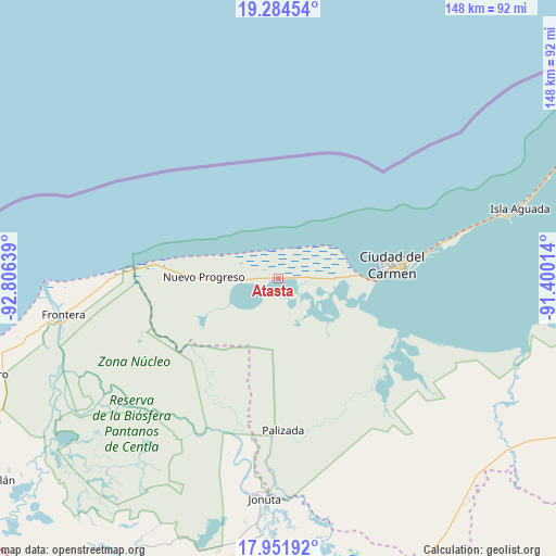
Atasta GPS coordinates[2]
18° 37' 10.344" North, 92° 6' 11.736" West
| Map corner | latitude | longitude |
|---|---|---|
| Upper-left | 19.28454°, | -92.80639° |
| Center: | 18.61954°, | -92.10326° |
| Lower-right: | 17.95192°, | -91.40014° |
| Map W x H: | 148.2×148.2 km | = 92.1×92.1mi |
| max Lat: | 32.7° ⇑71.2% North |
| Atasta: | 18.61954° |
| min Lat: | ⇓28.8% South 14.53588° |
| min Long | Atasta | max Long |
| -117.105° | -92.10326° | -86.73105° |
| W 94.8%⇐ | ⇒5.2% E |
Elevation
Elevation of Atasta is 4 m = 13 ft, and this is 1249.7 m = 4100 ft below average elevation for this country.
| Max E: |
3497 m = 11473 ft | 99.6% |
| Avg. | 1253.7 m = 4113 ft | |
| Atasta | 4 m = 13 ft | |
Min E: |
-1 m = -3 ft | 0.4% |
See also: Mexico elevation on elevation.city.
Geographical zone
Atasta is located in North Torrid zone (between Equator and Tropic of Cancer). Distance of this Northern Tropic circle is 535.6 km =332.8 mi to North.| Distance of | km | miles | from Atasta |
|---|---|---|---|
| North Pole | 7936.8 | 4931.7 | to North |
| Arctic Circle | 5330.9 | 3312.5 | to North |
| Tropic Cancer | 535.6 | 332.8 | to North |
| Equator | 2070.3 | 1286.4 | to South |


Nearby cities:
15 places around Atasta: (largest is in red/bold)
• Chichicastle 1ra. Sección
49.3 km =30.6 mi,  224°
224°
• Ciudad del Carmen
28.9 km =18 mi,  84°
84°
• Colonia Emiliano Zapata
22.5 km =14 mi,  283°
283°
• José María Pino Suárez
37 km =23 mi,  199°
199°
• La Estrella
50.5 km =31.4 mi,  267°
267°
• La Victoria
55.9 km =34.7 mi, 266°
• Nuevo Centla
44.5 km =27.7 mi, 270°
• Nuevo Progreso
19.8 km =12.3 mi, 271°
• Palizada
40.6 km =25.2 mi,  178°
178°
• Puerto Rico
17.3 km =10.7 mi,  89°
89°
• Ribera Alta 1ra. Sección
55.6 km =34.5 mi,  236°
236°
• Ribera Alta 2da. Sección (Salsipuedes)
51.8 km =32.2 mi, 235°
• San Antonio Cárdenas
12.7 km =7.9 mi, 267°
• San José
46.9 km =29.1 mi,  207°
207°
• Santa Isabel
31.5 km =19.6 mi, 178°
Sources, notices
• [Note1] Compared only with cities in Mexico existing in our database
• [Src1] Map data: © OpenStreetMap contributors (CC-BY-SA)
• [Src2] Other city data from geonames.org with taken over terms of usage.
• [Src3] Geographical zone / Annual Mean Temperature by Robert A. Rohde @ Wikipedia
