La Estrella geodata
La Estrella (Tabasco) is a populated place; located in Mexico in America/Mexico_City (GMT-6) time zone. With population of 1,083 people, there are 8040 cities with bigger population in this country. Compared to other cities in Mexico, 71.4% of cities are located further ↑North; 91.2% of cities are located further ←West and 99.6% of cities have higher elevation than La Estrella. Note1


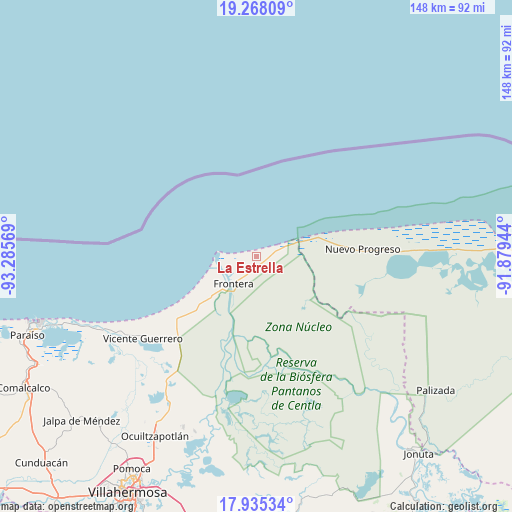
La Estrella GPS coordinates[2]
18° 36' 10.872" North, 92° 34' 57.216" West
| Map corner | latitude | longitude |
|---|---|---|
| Upper-left | 19.26809°, | -93.28569° |
| Center: | 18.60302°, | -92.58256° |
| Lower-right: | 17.93534°, | -91.87944° |
| Map W x H: | 148.2×148.2 km | = 92.1×92.1mi |
| max Lat: | 32.7° ⇑71.4% North |
| La Estrella: | 18.60302° |
| min Lat: | ⇓28.6% South 14.53588° |
| min Long | La Estrella | max Long |
| -117.105° | -92.58256° | -86.73105° |
| W 91.2%⇐ | ⇒8.8% E |
Elevation
Elevation of La Estrella is 4 m = 13 ft, and this is 1249.7 m = 4100 ft below average elevation for this country.
| Max E: |
3497 m = 11473 ft | 99.6% |
| Avg. | 1253.7 m = 4113 ft | |
| La Estrella | 4 m = 13 ft | |
Min E: |
-1 m = -3 ft | 0.4% |
See also: Mexico elevation on elevation.city.
Geographical zone
La Estrella is located in North Torrid zone (between Equator and Tropic of Cancer). Distance of this Northern Tropic circle is 537.5 km =334 mi to North.| Distance of | km | miles | from La Estrella |
|---|---|---|---|
| North Pole | 7938.6 | 4932.8 | to North |
| Arctic Circle | 5332.7 | 3313.6 | to North |
| Tropic Cancer | 537.5 | 334 | to North |
| Equator | 2068.5 | 1285.3 | to South |


Nearby cities:
15 places around La Estrella: (largest is in red/bold)
• Benito Juárez
30.5 km =19 mi,  229°
229°
• Carlos Rovirosa 1ra. Sección
7.6 km =4.7 mi,  240°
240°
• Colonia Emiliano Zapata
29.4 km =18.3 mi,  76°
76°
• Constancia y Venecia
31.5 km =19.6 mi, 233°
• Ejido Benito Juárez
30.1 km =18.7 mi, 235°
• Francisco I. Madero
21.8 km =13.5 mi, 226°
• Frontera
9.4 km =5.8 mi,  224°
224°
• La Victoria
5.5 km =3.4 mi,  255°
255°
• Nuevo Centla
6.4 km =4 mi,  69°
69°
• Nuevo Progreso
30.8 km =19.1 mi,  85°
85°
• Ribera Alta 1ra. Sección
29.4 km =18.3 mi,  171°
171°
• Ribera Alta 2da. Sección (Salsipuedes)
28.4 km =17.6 mi,  164°
164°
• San José del Carmen
29.7 km =18.5 mi, 226°
• Álvaro Obregón (Santa Cruz)
32.6 km =20.3 mi, 224°
• Álvaro Obregón 2da. Sección (El Lechugal)
32.1 km =19.9 mi, 223°
Sources, notices
• [Note1] Compared only with cities in Mexico existing in our database
• [Src1] Map data: © OpenStreetMap contributors (CC-BY-SA)
• [Src2] Other city data from geonames.org with taken over terms of usage.
• [Src3] Geographical zone / Annual Mean Temperature by Robert A. Rohde @ Wikipedia
