Pesquería Rancho Salinas geodata
Pesquería Rancho Salinas (Oaxaca) is a populated place; located in Mexico in America/Mexico_City (GMT-6) time zone. With population of 593 people, there are 14492 cities with bigger population in this country. Compared to other cities in Mexico, 96.3% of cities are located further ↑North; 85.7% of cities are located further ←West and 99.6% of cities have higher elevation than Pesquería Rancho Salinas. Note1
Current local time in Pesquería Rancho Salinas:
08:30 AM, WednesdayDifference from your time zone: hours


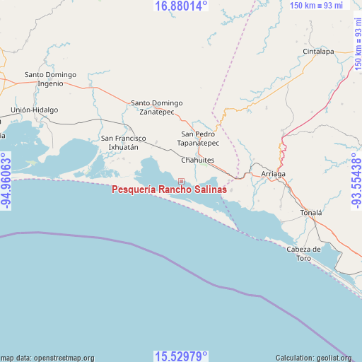
Pesquería Rancho Salinas GPS coordinates[2]
16° 12' 22.032" North, 94° 15' 27" West
| Map corner | latitude | longitude |
|---|---|---|
| Upper-left | 16.88014°, | -94.96063° |
| Center: | 16.20612°, | -94.2575° |
| Lower-right: | 15.52979°, | -93.55438° |
| Map W x H: | 150.1×150.1 km | = 93.3×93.3mi |
| max Lat: | 32.7° ⇑96.3% North |
| Pesquería Rancho Salinas: | 16.20612° |
| min Lat: | ⇓3.7% South 14.53588° |
| min Long | Pesquería Ranc | max Long |
| -117.105° | -94.2575° | -86.73105° |
| W 85.7%⇐ | ⇒14.3% E |
Elevation
Elevation of Pesquería Rancho Salinas is 4 m = 13 ft, and this is 1249.7 m = 4100 ft below average elevation for this country.
| Max E: |
3497 m = 11473 ft | 99.6% |
| Avg. | 1253.7 m = 4113 ft | |
| Pesquería Rancho Salinas | 4 m = 13 ft | |
Min E: |
-1 m = -3 ft | 0.4% |
See also: Mexico elevation on elevation.city.
Geographical zone
Pesquería Rancho Salinas is located in North Torrid zone (between Equator and Tropic of Cancer). Distance of this Northern Tropic circle is 804 km =499.6 mi to North.| Distance of | km | miles | from Pesquería Rancho Salinas |
|---|---|---|---|
| North Pole | 8205.1 | 5098.4 | to North |
| Arctic Circle | 5599.2 | 3479.2 | to North |
| Tropic Cancer | 804 | 499.6 | to North |
| Equator | 1802 | 1119.7 | to South |


Nearby cities:
15 places around Pesquería Rancho Salinas: (largest is in red/bold)
• 20 de Noviembre (El Morro)
25.6 km =15.9 mi,  291°
291°
• Chahuite
13.1 km =8.1 mi,  37°
37°
• Chahuites
11.3 km =7 mi, 36°
• El Espinal
24.4 km =15.2 mi, 42°
• Emiliano Zapata
20.9 km =13 mi,  99°
99°
• General Pascual Fentes
25.4 km =15.8 mi,  358°
358°
• La Gloria
18 km =11.2 mi,  112°
112°
• La Línea
25.1 km =15.6 mi, 109°
• Los Corazones
19.6 km =12.2 mi,  88°
88°
• Reforma de Pineda
30.4 km =18.9 mi,  315°
315°
• Rincón de Juárez
13.3 km =8.3 mi,  308°
308°
• San Francisco Ixhuatan
29.1 km =18.1 mi,  303°
303°
• San Pedro Tapanatepec
19.6 km =12.2 mi,  20°
20°
• Santa Rita (Santa Rita del Mar)
29.6 km =18.4 mi, 286°
• Yerba Santa
19.2 km =11.9 mi,  327°
327°
Sources, notices
• [Note1] Compared only with cities in Mexico existing in our database
• [Src1] Map data: © OpenStreetMap contributors (CC-BY-SA)
• [Src2] Other city data from geonames.org with taken over terms of usage.
• [Src3] Geographical zone / Annual Mean Temperature by Robert A. Rohde @ Wikipedia
