San Pedro Ñumí geodata
San Pedro Ñumí (Oaxaca) is a populated place; located in Mexico in America/Mexico_City (GMT-6) time zone. With population of 687 people, there are 12648 cities with bigger population in this country. Compared to other cities in Mexico, 84.4% of cities are located further ↑North; 67.7% of cities are located further ←West and 80.5% of cities have lower elevation than San Pedro Ñumí. Note1


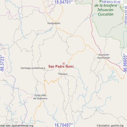
San Pedro Ñumí GPS coordinates[2]
17° 22' 37.992" North, 97° 40' 9.012" West
| Map corner | latitude | longitude |
|---|---|---|
| Upper-left | 18.04701°, | -98.3723° |
| Center: | 17.37722°, | -97.66917° |
| Lower-right: | 16.70497°, | -96.96605° |
| Map W x H: | 149.2×149.2 km | = 92.7×92.7mi |
| max Lat: | 32.7° ⇑84.4% North |
| San Pedro Ñumí: | 17.37722° |
| min Lat: | ⇓15.6% South 14.53588° |
| min Long | San Pedro Ñum� | max Long |
| -117.105° | -97.66917° | -86.73105° |
| W 67.7%⇐ | ⇒32.3% E |
Elevation
Elevation of San Pedro Ñumí is 2152 m = 7060 ft, and this is 898.3 m = 2947 ft above average elevation for this country.
| Max E: |
3497 m = 11473 ft | 19.5% |
| San Pedro Ñumí | 2152 m 7060 ft | |
| Avg. | 1253.7 m = 4113 ft | |
Min E: |
-1 m = -3 ft | 80.5% |
See also: Mexico elevation on elevation.city.
Geographical zone
San Pedro Ñumí is located in North Torrid zone (between Equator and Tropic of Cancer). Distance of this Northern Tropic circle is 673.8 km =418.7 mi to North.| Distance of | km | miles | from San Pedro Ñumí |
|---|---|---|---|
| North Pole | 8074.9 | 5017.5 | to North |
| Arctic Circle | 5469 | 3398.3 | to North |
| Tropic Cancer | 673.8 | 418.7 | to North |
| Equator | 1932.2 | 1200.6 | to South |


Nearby cities:
15 places around San Pedro Ñumí: (largest is in red/bold)
• Barrio San Diego
10.9 km =6.8 mi,  182°
182°
• Colonia Adolfo López Mateos
9 km =5.6 mi, 181°
• Heroica Ciudad de Tlaxiaco
12.1 km =7.5 mi,  185°
185°
• La Lobera
12.9 km =8 mi, 193°
• Sabinillo Ñumí
14.5 km =9 mi,  305°
305°
• San Cristóbal Amoltepec
14.6 km =9.1 mi,  135°
135°
• San Francisco Caballúa
13.6 km =8.5 mi,  338°
338°
• San José Monteverde
14.2 km =8.8 mi, 335°
• San Juan Ñumí
4.5 km =2.8 mi,  299°
299°
• San Pedro Mártir Yucuxaco
8.7 km =5.4 mi,  45°
45°
• Santa Catarina Tayata
12.2 km =7.6 mi,  105°
105°
• Santa Cruz Tayata
10.9 km =6.8 mi,  101°
101°
• Santa María del Rosario
8.3 km =5.2 mi, 109°
• Santiago Nundíche
5.1 km =3.2 mi, 185°
• Santiago Yolomécatl
14.9 km =9.3 mi,  44°
44°
Sources, notices
• [Note1] Compared only with cities in Mexico existing in our database
• [Src1] Map data: © OpenStreetMap contributors (CC-BY-SA)
• [Src2] Other city data from geonames.org with taken over terms of usage.
• [Src3] Geographical zone / Annual Mean Temperature by Robert A. Rohde @ Wikipedia
