La Palma geodata
La Palma (Tabasco) is a populated place; located in Mexico in America/Mexico_City (GMT-6) time zone. With population of 1,427 people, there are 6051 cities with bigger population in this country. Compared to other cities in Mexico, 78.9% of cities are located further ↑North; 89.8% of cities are located further ←West and 89.7% of cities have higher elevation than La Palma. Note1


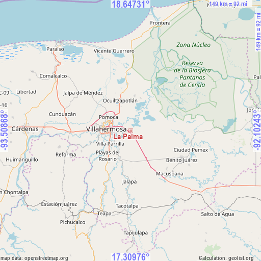
La Palma GPS coordinates[2]
17° 58' 47.28" North, 92° 48' 19.98" West
| Map corner | latitude | longitude |
|---|---|---|
| Upper-left | 18.64731°, | -93.50868° |
| Center: | 17.9798°, | -92.80555° |
| Lower-right: | 17.30976°, | -92.10243° |
| Map W x H: | 148.7×148.7 km | = 92.4×92.4mi |
| max Lat: | 32.7° ⇑78.9% North |
| La Palma: | 17.9798° |
| min Lat: | ⇓21.1% South 14.53588° |
| min Long | La Palma | max Long |
| -117.105° | -92.80555° | -86.73105° |
| W 89.8%⇐ | ⇒10.2% E |
Elevation
Elevation of La Palma is 25 m = 82 ft, and this is 1228.7 m = 4031 ft below average elevation for this country.
| Max E: |
3497 m = 11473 ft | 89.7% |
| Avg. | 1253.7 m = 4113 ft | |
| La Palma | 25 m = 82 ft | |
Min E: |
-1 m = -3 ft | 10.3% |
See also: Mexico elevation on elevation.city.
Geographical zone
La Palma is located in North Torrid zone (between Equator and Tropic of Cancer). Distance of this Northern Tropic circle is 606.8 km =377 mi to North.| Distance of | km | miles | from La Palma |
|---|---|---|---|
| North Pole | 8007.9 | 4975.9 | to North |
| Arctic Circle | 5402 | 3356.6 | to North |
| Tropic Cancer | 606.8 | 377 | to North |
| Equator | 1999.2 | 1242.2 | to South |


Nearby cities:
15 places around La Palma: (largest is in red/bold)
• Acachapan y Colmena 2da. Sección (La Arena)
7.8 km =4.8 mi,  344°
344°
• Acachapan y Colmena 3ra. Sección
8.2 km =5.1 mi,  21°
21°
• Barrancas y Amate 3ra. Sección
4.7 km =2.9 mi,  101°
101°
• Constitución
12.5 km =7.8 mi,  325°
325°
• Dos Montes
2.6 km =1.6 mi,  290°
290°
• El Bajío
2.5 km =1.6 mi,  85°
85°
• El Corozal
6.1 km =3.8 mi,  66°
66°
• Gaviotas Sur (El Cedral)
9.5 km =5.9 mi,  252°
252°
• La Cruz del Bajío
1.9 km =1.2 mi,  106°
106°
• La Manga 2da. Sección (El Jobal)
8.1 km =5 mi,  302°
302°
• Lagartera 1ra. Sección
12.5 km =7.8 mi,  317°
317°
• Medellín y Pigua 1ra. Sección
12.6 km =7.8 mi, 295°
• Miraflores 3ra. Sección
10.3 km =6.4 mi,  125°
125°
• Pajonal
1.8 km =1.1 mi,  32°
32°
• Plutarco Elías Calles (Cura Hueso)
12.2 km =7.6 mi,  262°
262°
Sources, notices
• [Note1] Compared only with cities in Mexico existing in our database
• [Src1] Map data: © OpenStreetMap contributors (CC-BY-SA)
• [Src2] Other city data from geonames.org with taken over terms of usage.
• [Src3] Geographical zone / Annual Mean Temperature by Robert A. Rohde @ Wikipedia
