Lagartera 1ra. Sección geodata
Lagartera 1ra. Sección (Tabasco) is a populated place; located in Mexico in America/Mexico_City (GMT-6) time zone. With population of 1,914 people, there are 4541 cities with bigger population in this country. Compared to other cities in Mexico, 78% of cities are located further ↑North; 89.3% of cities are located further ←West and 98.1% of cities have higher elevation than Lagartera 1ra. Sección. Note1
Current local time in Lagartera 1ra. Sección:
06:53 AM, WednesdayDifference from your time zone: hours


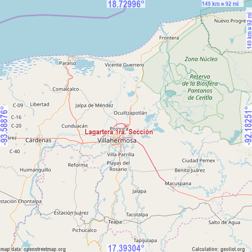
Lagartera 1ra. Sección GPS coordinates[2]
18° 3' 45.972" North, 92° 53' 8.268" West
| Map corner | latitude | longitude |
|---|---|---|
| Upper-left | 18.72996°, | -93.58876° |
| Center: | 18.06277°, | -92.88563° |
| Lower-right: | 17.39304°, | -92.18251° |
| Map W x H: | 148.7×148.7 km | = 92.4×92.4mi |
| max Lat: | 32.7° ⇑78% North |
| Lagartera 1ra. Sección: | 18.06277° |
| min Lat: | ⇓22% South 14.53588° |
| min Long | Lagartera 1ra. | max Long |
| -117.105° | -92.88563° | -86.73105° |
| W 89.3%⇐ | ⇒10.7% E |
Elevation
Elevation of Lagartera 1ra. Sección is 8 m = 26 ft, and this is 1245.7 m = 4087 ft below average elevation for this country.
| Max E: |
3497 m = 11473 ft | 98.1% |
| Avg. | 1253.7 m = 4113 ft | |
| Lagartera 1ra. Sección | 8 m = 26 ft | |
Min E: |
-1 m = -3 ft | 1.9% |
See also: Mexico elevation on elevation.city.
Geographical zone
Lagartera 1ra. Sección is located in North Torrid zone (between Equator and Tropic of Cancer). Distance of this Northern Tropic circle is 597.5 km =371.3 mi to North.| Distance of | km | miles | from Lagartera 1ra. Sección |
|---|---|---|---|
| North Pole | 7998.7 | 4970.2 | to North |
| Arctic Circle | 5392.8 | 3350.9 | to North |
| Tropic Cancer | 597.5 | 371.3 | to North |
| Equator | 2008.4 | 1248 | to South |


Nearby cities:
15 places around Lagartera 1ra. Sección: (largest is in red/bold)
• Acachapan y Colmena 2da. Sección (La Arena)
6.7 km =4.2 mi,  105°
105°
• Constitución
1.8 km =1.1 mi,  52°
52°
• El Cedro
7.7 km =4.8 mi,  238°
238°
• El Tigre
7.4 km =4.6 mi,  306°
306°
• Fraccionamiento Ocuiltzapotlán Dos
5.5 km =3.4 mi,  20°
20°
• Francisco I. Madero 1ra. Sección
7.3 km =4.5 mi,  31°
31°
• La Manga 2da. Sección (El Jobal)
5.1 km =3.2 mi,  160°
160°
• Lomitas
8.1 km =5 mi,  271°
271°
• Los Sauces
4.7 km =2.9 mi,  225°
225°
• Medellín y Madero Segunda Sección
6.6 km =4.1 mi, 30°
• Medellín y Pigua 1ra. Sección
4.7 km =2.9 mi,  217°
217°
• Pomoca
5 km =3.1 mi,  253°
253°
• Saloya 2da. Sección
5.5 km =3.4 mi,  258°
258°
• Samarkanda
3.5 km =2.2 mi, 228°
• Tierra Amarilla 3ra. Sección
1.4 km =0.9 mi,  283°
283°
Sources, notices
• [Note1] Compared only with cities in Mexico existing in our database
• [Src1] Map data: © OpenStreetMap contributors (CC-BY-SA)
• [Src2] Other city data from geonames.org with taken over terms of usage.
• [Src3] Geographical zone / Annual Mean Temperature by Robert A. Rohde @ Wikipedia
