Pedregal de San José geodata
Pedregal de San José (Hidalgo) is a populated place; located in Mexico in America/Mexico_City (GMT-6) time zone. With population of 2,753 people, there are 3216 cities with bigger population in this country. Compared to other cities in Mexico, 58.5% of cities are located further ↓South; 58.5% of cities are located further ←West and 81.6% of cities have lower elevation than Pedregal de San José. Note1


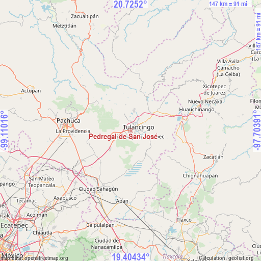
Pedregal de San José GPS coordinates[2]
20° 3' 58.176" North, 98° 24' 25.308" West
| Map corner | latitude | longitude |
|---|---|---|
| Upper-left | 20.7252°, | -99.11016° |
| Center: | 20.06616°, | -98.40703° |
| Lower-right: | 19.40434°, | -97.70391° |
| Map W x H: | 146.9×146.9 km | = 91.3×91.3mi |
| max Lat: | 32.7° ⇑41.5% North |
| Pedregal de San José: | 20.06616° |
| min Lat: | ⇓58.5% South 14.53588° |
| min Long | Pedregal de San | max Long |
| -117.105° | -98.40703° | -86.73105° |
| W 58.5%⇐ | ⇒41.5% E |
Elevation
Elevation of Pedregal de San José is 2179 m = 7149 ft, and this is 925.3 m = 3036 ft above average elevation for this country.
| Max E: |
3497 m = 11473 ft | 18.4% |
| Pedregal de San José | 2179 m 7149 ft | |
| Avg. | 1253.7 m = 4113 ft | |
Min E: |
-1 m = -3 ft | 81.6% |
See also: Mexico elevation on elevation.city.
Geographical zone
Pedregal de San José is located in North Torrid zone (between Equator and Tropic of Cancer). Distance of this Northern Tropic circle is 374.8 km =232.9 mi to North.| Distance of | km | miles | from Pedregal de San José |
|---|---|---|---|
| North Pole | 7775.9 | 4831.7 | to North |
| Arctic Circle | 5170 | 3212.5 | to North |
| Tropic Cancer | 374.8 | 232.9 | to North |
| Equator | 2231.1 | 1386.3 | to South |


Nearby cities:
15 places around Pedregal de San José: (largest is in red/bold)
• Ahuehuetitla
2.3 km =1.4 mi,  333°
333°
• Colonia Felipe Ángeles
1.8 km =1.1 mi,  222°
222°
• Emiliano Zapata
1.3 km =0.8 mi,  357°
357°
• Fraccionamiento del Magisterio Tulancinguense
1.4 km =0.9 mi,  33°
33°
• Javier Rojo Gómez
1.2 km =0.7 mi,  289°
289°
• La Joya
4.1 km =2.5 mi,  131°
131°
• Los Romeros
4.1 km =2.5 mi,  191°
191°
• Paxtepec
2.9 km =1.8 mi,  239°
239°
• Pedregal de San Francisco
0.4 km =0.2 mi,  86°
86°
• San Antonio Farías
3 km =1.9 mi,  19°
19°
• San Antonio Farías (Colonia Camino Real)
2.8 km =1.7 mi, 28°
• San Nicolás el Chico
3.9 km =2.4 mi, 31°
• Santa María el Chico
4.7 km =2.9 mi,  13°
13°
• Tulancingo
5 km =3.1 mi,  67°
67°
• Unidades Habitacionales
1.4 km =0.9 mi,  259°
259°
Sources, notices
• [Note1] Compared only with cities in Mexico existing in our database
• [Src1] Map data: © OpenStreetMap contributors (CC-BY-SA)
• [Src2] Other city data from geonames.org with taken over terms of usage.
• [Src3] Geographical zone / Annual Mean Temperature by Robert A. Rohde @ Wikipedia
