La Joya geodata
La Joya (Hidalgo) is a populated place; located in Mexico in America/Mexico_City (GMT-6) time zone. With population of 686 people, there are 12663 cities with bigger population in this country. Compared to other cities in Mexico, 57.9% of cities are located further ↓South; 58.9% of cities are located further ←West and 81.8% of cities have lower elevation than La Joya. Note1


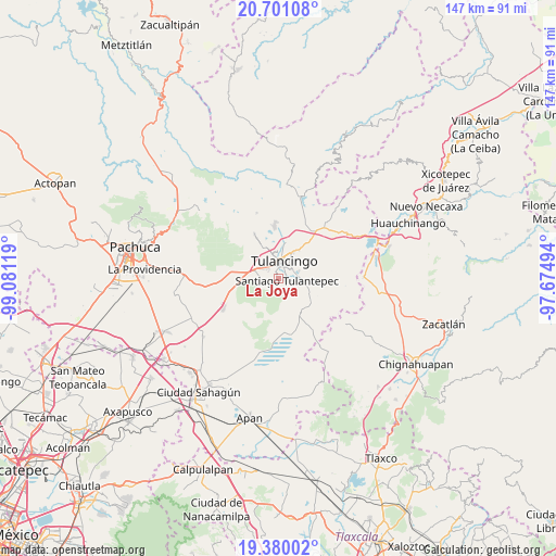
La Joya GPS coordinates[2]
20° 2' 30.984" North, 98° 22' 41.016" West
| Map corner | latitude | longitude |
|---|---|---|
| Upper-left | 20.70108°, | -99.08119° |
| Center: | 20.04194°, | -98.37806° |
| Lower-right: | 19.38002°, | -97.67494° |
| Map W x H: | 146.9×146.9 km | = 91.3×91.3mi |
| max Lat: | 32.7° ⇑42.1% North |
| La Joya: | 20.04194° |
| min Lat: | ⇓57.9% South 14.53588° |
| min Long | La Joya | max Long |
| -117.105° | -98.37806° | -86.73105° |
| W 58.9%⇐ | ⇒41.1% E |
Elevation
Elevation of La Joya is 2184 m = 7165 ft, and this is 930.3 m = 3052 ft above average elevation for this country.
| Max E: |
3497 m = 11473 ft | 18.2% |
| La Joya | 2184 m 7165 ft | |
| Avg. | 1253.7 m = 4113 ft | |
Min E: |
-1 m = -3 ft | 81.8% |
See also: Mexico elevation on elevation.city.
Geographical zone
La Joya is located in North Torrid zone (between Equator and Tropic of Cancer). Distance of this Northern Tropic circle is 377.5 km =234.6 mi to North.| Distance of | km | miles | from La Joya |
|---|---|---|---|
| North Pole | 7778.6 | 4833.4 | to North |
| Arctic Circle | 5172.7 | 3214.2 | to North |
| Tropic Cancer | 377.5 | 234.6 | to North |
| Equator | 2228.5 | 1384.7 | to South |


Nearby cities:
15 places around La Joya: (largest is in red/bold)
• Colonia Felipe Ángeles
4.4 km =2.7 mi,  287°
287°
• Emiliano Zapata
5 km =3.1 mi,  322°
322°
• Fraccionamiento del Magisterio Tulancinguense
4.4 km =2.7 mi,  329°
329°
• Javier Rojo Gómez
5.2 km =3.2 mi,  306°
306°
• Los Romeros
4.1 km =2.5 mi,  250°
250°
• Paxtepec
5.7 km =3.5 mi,  282°
282°
• Pedregal de San Francisco
3.8 km =2.4 mi, 315°
• Pedregal de San José
4.1 km =2.5 mi, 311°
• San Antonio Farías (Colonia Camino Real)
5.4 km =3.4 mi,  342°
342°
• Santiago Tulantepec
2.4 km =1.5 mi,  105°
105°
• Texcaltepec
5.8 km =3.6 mi,  102°
102°
• Tezoquipa
4.5 km =2.8 mi, 102°
• Tulancingo
4.9 km =3 mi,  18°
18°
• Unidades Habitacionales
5.1 km =3.2 mi,  298°
298°
• Ventoquipa
4.3 km =2.7 mi, 102°
Sources, notices
• [Note1] Compared only with cities in Mexico existing in our database
• [Src1] Map data: © OpenStreetMap contributors (CC-BY-SA)
• [Src2] Other city data from geonames.org with taken over terms of usage.
• [Src3] Geographical zone / Annual Mean Temperature by Robert A. Rohde @ Wikipedia
