Agrónomos Mexicanos geodata
Agrónomos Mexicanos (Chiapas) is a populated place; located in Mexico in America/Mexico_City (GMT-6) time zone. With population of 1,202 people, there are 7230 cities with bigger population in this country. Compared to other cities in Mexico, 95.3% of cities are located further ↑North; 86.5% of cities are located further ←West and 65.3% of cities have higher elevation than Agrónomos Mexicanos. Note1


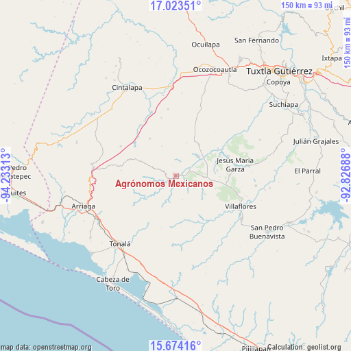
Agrónomos Mexicanos GPS coordinates[2]
16° 21' 0" North, 93° 31' 48" West
| Map corner | latitude | longitude |
|---|---|---|
| Upper-left | 17.02351°, | -94.23313° |
| Center: | 16.35°, | -93.53° |
| Lower-right: | 15.67416°, | -92.82688° |
| Map W x H: | 150×150 km | = 93.2×93.2mi |
| max Lat: | 32.7° ⇑95.3% North |
| Agrónomos Mexicanos: | 16.35° |
| min Lat: | ⇓4.7% South 14.53588° |
| min Long | Agrónomos Mexi | max Long |
| -117.105° | -93.53° | -86.73105° |
| W 86.5%⇐ | ⇒13.5% E |
Elevation
Elevation of Agrónomos Mexicanos is 668 m = 2192 ft, and this is 585.7 m = 1922 ft below average elevation for this country.
| Max E: |
3497 m = 11473 ft | 65.3% |
| Avg. | 1253.7 m = 4113 ft | |
| Agrónomos Mexicanos | 668 m = 2192 ft | |
Min E: |
-1 m = -3 ft | 34.7% |
See also: Mexico elevation on elevation.city.
Geographical zone
Agrónomos Mexicanos is located in North Torrid zone (between Equator and Tropic of Cancer). Distance of this Northern Tropic circle is 788 km =489.6 mi to North.| Distance of | km | miles | from Agrónomos Mexicanos |
|---|---|---|---|
| North Pole | 8189.1 | 5088.5 | to North |
| Arctic Circle | 5583.2 | 3469.2 | to North |
| Tropic Cancer | 788 | 489.6 | to North |
| Equator | 1817.9 | 1129.6 | to South |


Nearby cities:
15 places around Agrónomos Mexicanos: (largest is in red/bold)
• Calzada Larga
22.9 km =14.2 mi,  89°
89°
• Cristóbal Obregón
0.4 km =0.2 mi,  270°
270°
• Cristóbal Obregón
12 km =7.5 mi,  40°
40°
• Doctor Domingo Chanona
12.1 km =7.5 mi, 92°
• Joaquín Miguel Gutiérrez
17.7 km =11 mi,  82°
82°
• Julián Grajales
21.5 km =13.4 mi,  294°
294°
• Libertad Melchor Ocampo
6.4 km =4 mi,  65°
65°
• Los Ángeles
14.7 km =9.1 mi,  232°
232°
• Luis Espinosa
14.1 km =8.8 mi,  334°
334°
• Nueva Palestina
19.3 km =12 mi, 325°
• Nuevo México
16.5 km =10.3 mi, 36°
• Tenochtitlán
21.5 km =13.4 mi,  56°
56°
• Tierra y Libertad
22.4 km =13.9 mi,  235°
235°
• Unión Agrarista
21.2 km =13.2 mi,  311°
311°
• Úrsulo Galván
14.6 km =9.1 mi,  122°
122°
Sources, notices
• [Note1] Compared only with cities in Mexico existing in our database
• [Src1] Map data: © OpenStreetMap contributors (CC-BY-SA)
• [Src2] Other city data from geonames.org with taken over terms of usage.
• [Src3] Geographical zone / Annual Mean Temperature by Robert A. Rohde @ Wikipedia
