San Diego Texmelucan geodata
San Diego Texmelucan (Puebla) is a populated place; located in Mexico in America/Mexico_City (GMT-6) time zone. With population of 670 people, there are 12949 cities with bigger population in this country. Compared to other cities in Mexico, 64.3% of cities are located further ↑North; 70% of cities are located further ←West and 95% of cities have lower elevation than San Diego Texmelucan. Note1
Current local time in San Diego Texmelucan:
02:18 PM, WednesdayDifference from your time zone: hours


San Diego Texmelucan GPS coordinates[2]
19° 1' 12.468" North, 97° 27' 10.98" West
| Map corner | latitude | longitude |
|---|---|---|
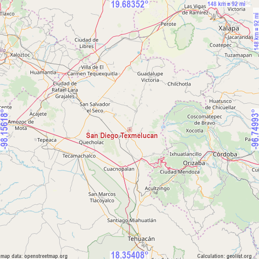
| Upper-left | 19.68352°, | -98.15618° |
| Center: | 19.02013°, | -97.45305° |
| Lower-right: | 18.35408°, | -96.74993° |
| Map W x H: | 147.8×147.8 km | = 91.8×91.8mi |
| max Lat: | 32.7° ⇑64.3% North |
| San Diego Texmelucan: | 19.02013° |
| min Lat: | ⇓35.7% South 14.53588° |
| min Long | San Diego Texme | max Long |
| -117.105° | -97.45305° | -86.73105° |
| W 70%⇐ | ⇒30% E |
Elevation
Elevation of San Diego Texmelucan is 2596 m = 8517 ft, and this is 1342.3 m = 4404 ft above average elevation for this country.
| Max E: |
3497 m = 11473 ft | 5% |
| San Diego Texmelucan | 2596 m 8517 ft | |
| Avg. | 1253.7 m = 4113 ft | |
Min E: |
-1 m = -3 ft | 95% |
See also: Mexico elevation on elevation.city.
Geographical zone
San Diego Texmelucan is located in North Torrid zone (between Equator and Tropic of Cancer). Distance of this Northern Tropic circle is 491.1 km =305.2 mi to North.| Distance of | km | miles | from San Diego Texmelucan |
|---|---|---|---|
| North Pole | 7892.2 | 4904 | to North |
| Arctic Circle | 5286.3 | 3284.8 | to North |
| Tropic Cancer | 491.1 | 305.2 | to North |
| Equator | 2114.8 | 1314.1 | to South |


Nearby cities:
15 places around San Diego Texmelucan: (largest is in red/bold)
• Ahuatepec de Camino
3 km =1.9 mi,  40°
40°
• Ciudad Serdán
3.6 km =2.2 mi,  168°
168°
• El Veladero
7 km =4.3 mi,  206°
206°
• Manuel Edgardo Ávalos (San Isidro)
8.3 km =5.2 mi,  50°
50°
• San Francisco Cuautlancingo
4.8 km =3 mi,  122°
122°
• San Francisco Independencia (Santa María Aserradero)
5.9 km =3.7 mi,  23°
23°
• San Isidro Canoas Altas
11.4 km =7.1 mi,  111°
111°
• San José Guerrero
9.4 km =5.8 mi,  252°
252°
• San José Llano Grande
11 km =6.8 mi,  71°
71°
• San Martín Ojo de Agua
6.5 km =4 mi,  97°
97°
• San Miguel Ocotenco
5.2 km =3.2 mi,  0°
0°
• Santa Cruz Coyotepec
11.3 km =7 mi,  271°
271°
• Santa María Techachalco
7.6 km =4.7 mi,  193°
193°
• Santa María el Aserradero (Peones Acasillados)
9.2 km =5.7 mi, 51°
• Tlachichuca
11.1 km =6.9 mi, 18°
Sources, notices
• [Note1] Compared only with cities in Mexico existing in our database
• [Src1] Map data: © OpenStreetMap contributors (CC-BY-SA)
• [Src2] Other city data from geonames.org with taken over terms of usage.
• [Src3] Geographical zone / Annual Mean Temperature by Robert A. Rohde @ Wikipedia
