Tlachichuca geodata
Tlachichuca (Puebla) is a populated place; located in Mexico in America/Mexico_City (GMT-6) time zone. With population of 7,574 people, there are 1230 cities with bigger population in this country. Compared to other cities in Mexico, 62.8% of cities are located further ↑North; 70.4% of cities are located further ←West and 95.7% of cities have lower elevation than Tlachichuca. Note1


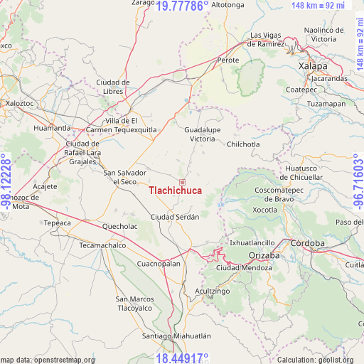
Tlachichuca GPS coordinates[2]
19° 6' 53.46" North, 97° 25' 8.94" West
| Map corner | latitude | longitude |
|---|---|---|
| Upper-left | 19.77786°, | -98.12228° |
| Center: | 19.11485°, | -97.41915° |
| Lower-right: | 18.44917°, | -96.71603° |
| Map W x H: | 147.7×147.7 km | = 91.8×91.8mi |
| max Lat: | 32.7° ⇑62.8% North |
| Tlachichuca: | 19.11485° |
| min Lat: | ⇓37.2% South 14.53588° |
| min Long | Tlachichuca | max Long |
| -117.105° | -97.41915° | -86.73105° |
| W 70.4%⇐ | ⇒29.6% E |
Elevation
Elevation of Tlachichuca is 2616 m = 8583 ft, and this is 1362.3 m = 4469 ft above average elevation for this country.
| Max E: |
3497 m = 11473 ft | 4.3% |
| Tlachichuca | 2616 m 8583 ft | |
| Avg. | 1253.7 m = 4113 ft | |
Min E: |
-1 m = -3 ft | 95.7% |
See also: Mexico elevation on elevation.city.
Geographical zone
Tlachichuca is located in North Torrid zone (between Equator and Tropic of Cancer). Distance of this Northern Tropic circle is 480.5 km =298.6 mi to North.| Distance of | km | miles | from Tlachichuca |
|---|---|---|---|
| North Pole | 7881.7 | 4897.5 | to North |
| Arctic Circle | 5275.8 | 3278.2 | to North |
| Tropic Cancer | 480.5 | 298.6 | to North |
| Equator | 2125.4 | 1320.7 | to South |


Nearby cities:
15 places around Tlachichuca: (largest is in red/bold)
• Ahuatepec de Camino
8.4 km =5.2 mi,  191°
191°
• Emancipación Quetzalapa
7.1 km =4.4 mi,  23°
23°
• Guadalupe Libertad
8.8 km =5.5 mi, 22°
• José María Morelos
5.9 km =3.7 mi,  299°
299°
• Lázaro Cárdenas
3.7 km =2.3 mi,  31°
31°
• Manuel Edgardo Ávalos (San Isidro)
6 km =3.7 mi,  151°
151°
• Paso Nacional
7.2 km =4.5 mi,  63°
63°
• Rafael Avila Camacho
1.4 km =0.9 mi, 28°
• San Francisco Independencia (Santa María Aserradero)
5.2 km =3.2 mi, 192°
• San Miguel Ocotenco
6.4 km =4 mi,  213°
213°
• San Miguel Zoapan
7.7 km =4.8 mi,  116°
116°
• Santa Cecilia Tepetitlán
8.8 km =5.5 mi,  349°
349°
• Santa Inés Varela la Luz
5.5 km =3.4 mi,  35°
35°
• Santa María el Aserradero (Peones Acasillados)
6.1 km =3.8 mi,  142°
142°
• Álamos Tepetitlán
9.3 km =5.8 mi, 347°
Sources, notices
• [Note1] Compared only with cities in Mexico existing in our database
• [Src1] Map data: © OpenStreetMap contributors (CC-BY-SA)
• [Src2] Other city data from geonames.org with taken over terms of usage.
• [Src3] Geographical zone / Annual Mean Temperature by Robert A. Rohde @ Wikipedia
