Telpatlán geodata
Telpatlán (Puebla) is a populated place; located in Mexico in America/Mexico_City (GMT-6) time zone. With population of 2,532 people, there are 3503 cities with bigger population in this country. Compared to other cities in Mexico, 72.8% of cities are located further ↑North; 73% of cities are located further ←West and 90.8% of cities have lower elevation than Telpatlán. Note1


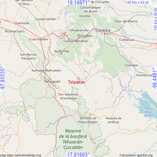
Telpatlán GPS coordinates[2]
18° 29' 3.012" North, 97° 9' 7.992" West
| Map corner | latitude | longitude |
|---|---|---|
| Upper-left | 19.14971°, | -97.85535° |
| Center: | 18.48417°, | -97.15222° |
| Lower-right: | 17.81603°, | -96.4491° |
| Map W x H: | 148.3×148.3 km | = 92.1×92.1mi |
| max Lat: | 32.7° ⇑72.8% North |
| Telpatlán: | 18.48417° |
| min Lat: | ⇓27.2% South 14.53588° |
| min Long | Telpatlán | max Long |
| -117.105° | -97.15222° | -86.73105° |
| W 73%⇐ | ⇒27% E |
Elevation
Elevation of Telpatlán is 2434 m = 7986 ft, and this is 1180.3 m = 3872 ft above average elevation for this country.
| Max E: |
3497 m = 11473 ft | 9.2% |
| Telpatlán | 2434 m 7986 ft | |
| Avg. | 1253.7 m = 4113 ft | |
Min E: |
-1 m = -3 ft | 90.8% |
See also: Mexico elevation on elevation.city.
Geographical zone
Telpatlán is located in North Torrid zone (between Equator and Tropic of Cancer). Distance of this Northern Tropic circle is 550.7 km =342.2 mi to North.| Distance of | km | miles | from Telpatlán |
|---|---|---|---|
| North Pole | 7951.8 | 4941 | to North |
| Arctic Circle | 5345.9 | 3321.8 | to North |
| Tropic Cancer | 550.7 | 342.2 | to North |
| Equator | 2055.2 | 1277 | to South |


Nearby cities:
15 places around Telpatlán: (largest is in red/bold)
• Acuayucan
8.3 km =5.2 mi,  30°
30°
• Antiguo Caporalco
6.3 km =3.9 mi,  350°
350°
• Caporalco Buenos Aires
3.9 km =2.4 mi,  359°
359°
• Cuatro Caminos
2.6 km =1.6 mi,  72°
72°
• Cuautotolapan (San José)
6.6 km =4.1 mi,  149°
149°
• Loma Bonita
7 km =4.3 mi,  85°
85°
• Moyotepec
8.1 km =5 mi,  118°
118°
• Santa María del Monte
8.1 km =5 mi,  321°
321°
• Tepeica
8 km =5 mi,  53°
53°
• Tepetzitzintla
3.7 km =2.3 mi,  111°
111°
• Tulimanca
2.1 km =1.3 mi,  141°
141°
• Vista Hermosa Zayulapa
8.2 km =5.1 mi, 136°
• Xochitzinga
4.5 km =2.8 mi, 146°
• Xonacayojca
6.9 km =4.3 mi,  62°
62°
• Xopilapa
8 km =5 mi, 73°
Sources, notices
• [Note1] Compared only with cities in Mexico existing in our database
• [Src1] Map data: © OpenStreetMap contributors (CC-BY-SA)
• [Src2] Other city data from geonames.org with taken over terms of usage.
• [Src3] Geographical zone / Annual Mean Temperature by Robert A. Rohde @ Wikipedia
