Cuatro Caminos geodata
Cuatro Caminos (Puebla) is a populated place; located in Mexico in America/Mexico_City (GMT-6) time zone. With population of 1,236 people, there are 7022 cities with bigger population in this country. Compared to other cities in Mexico, 72.7% of cities are located further ↑North; 73.2% of cities are located further ←West and 90.4% of cities have lower elevation than Cuatro Caminos. Note1


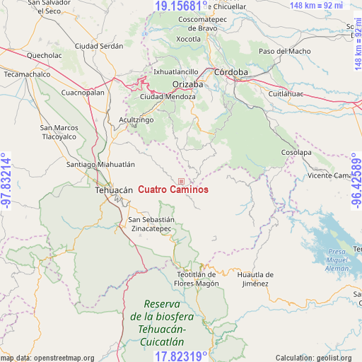
Cuatro Caminos GPS coordinates[2]
18° 29' 28.68" North, 97° 7' 44.436" West
| Map corner | latitude | longitude |
|---|---|---|
| Upper-left | 19.15681°, | -97.83214° |
| Center: | 18.4913°, | -97.12901° |
| Lower-right: | 17.82319°, | -96.42589° |
| Map W x H: | 148.3×148.3 km | = 92.1×92.1mi |
| max Lat: | 32.7° ⇑72.7% North |
| Cuatro Caminos: | 18.4913° |
| min Lat: | ⇓27.3% South 14.53588° |
| min Long | Cuatro Caminos | max Long |
| -117.105° | -97.12901° | -86.73105° |
| W 73.2%⇐ | ⇒26.8% E |
Elevation
Elevation of Cuatro Caminos is 2421 m = 7943 ft, and this is 1167.3 m = 3830 ft above average elevation for this country.
| Max E: |
3497 m = 11473 ft | 9.6% |
| Cuatro Caminos | 2421 m 7943 ft | |
| Avg. | 1253.7 m = 4113 ft | |
Min E: |
-1 m = -3 ft | 90.4% |
See also: Mexico elevation on elevation.city.
Geographical zone
Cuatro Caminos is located in North Torrid zone (between Equator and Tropic of Cancer). Distance of this Northern Tropic circle is 549.9 km =341.7 mi to North.| Distance of | km | miles | from Cuatro Caminos |
|---|---|---|---|
| North Pole | 7951 | 4940.5 | to North |
| Arctic Circle | 5345.1 | 3321.3 | to North |
| Tropic Cancer | 549.9 | 341.7 | to North |
| Equator | 2056 | 1277.5 | to South |


Nearby cities:
15 places around Cuatro Caminos: (largest is in red/bold)
• Acatitla
7 km =4.3 mi,  5°
5°
• Acuayucan
6.6 km =4.1 mi,  16°
16°
• Antiguo Caporalco
6.4 km =4 mi,  327°
327°
• Caporalco Buenos Aires
4 km =2.5 mi,  320°
320°
• Cuautotolapan (San José)
6.5 km =4 mi,  172°
172°
• Loma Bonita
4.6 km =2.9 mi,  93°
93°
• Moyotepec
6.6 km =4.1 mi,  135°
135°
• Telpatlán
2.6 km =1.6 mi,  252°
252°
• Tepecuitlapa
6.2 km =3.9 mi, 92°
• Tepeica
5.6 km =3.5 mi,  44°
44°
• Tepetzitzintla
2.4 km =1.5 mi,  154°
154°
• Tulimanca
2.7 km =1.7 mi,  205°
205°
• Xochitzinga
4.6 km =2.9 mi,  179°
179°
• Xonacayojca
4.4 km =2.7 mi,  57°
57°
• Xopilapa
5.4 km =3.4 mi,  74°
74°
Sources, notices
• [Note1] Compared only with cities in Mexico existing in our database
• [Src1] Map data: © OpenStreetMap contributors (CC-BY-SA)
• [Src2] Other city data from geonames.org with taken over terms of usage.
• [Src3] Geographical zone / Annual Mean Temperature by Robert A. Rohde @ Wikipedia
