Tototepec geodata
Tototepec (Guerrero) is a populated place; located in Mexico in America/Mexico_City (GMT-6) time zone. With population of 2,836 people, there are 3130 cities with bigger population in this country. Compared to other cities in Mexico, 83.8% of cities are located further ↑North; 56.2% of cities are located further ←West and 57.5% of cities have lower elevation than Tototepec. Note1


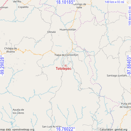
Tototepec GPS coordinates[2]
17° 25' 56.172" North, 98° 35' 13.74" West
| Map corner | latitude | longitude |
|---|---|---|
| Upper-left | 18.10185°, | -99.29028° |
| Center: | 17.43227°, | -98.58715° |
| Lower-right: | 16.76022°, | -97.88403° |
| Map W x H: | 149.2×149.2 km | = 92.7×92.7mi |
| max Lat: | 32.7° ⇑83.8% North |
| Tototepec: | 17.43227° |
| min Lat: | ⇓16.2% South 14.53588° |
| min Long | Tototepec | max Long |
| -117.105° | -98.58715° | -86.73105° |
| W 56.2%⇐ | ⇒43.8% E |
Elevation
Elevation of Tototepec is 1677 m = 5502 ft, and this is 423.3 m = 1389 ft above average elevation for this country.
| Max E: |
3497 m = 11473 ft | 42.5% |
| Tototepec | 1677 m 5502 ft | |
| Avg. | 1253.7 m = 4113 ft | |
Min E: |
-1 m = -3 ft | 57.5% |
See also: Mexico elevation on elevation.city.
Geographical zone
Tototepec is located in North Torrid zone (between Equator and Tropic of Cancer). Distance of this Northern Tropic circle is 667.6 km =414.8 mi to North.| Distance of | km | miles | from Tototepec |
|---|---|---|---|
| North Pole | 8068.8 | 5013.7 | to North |
| Arctic Circle | 5462.9 | 3394.5 | to North |
| Tropic Cancer | 667.6 | 414.8 | to North |
| Equator | 1938.3 | 1204.4 | to South |


Nearby cities:
15 places around Tototepec: (largest is in red/bold)
• Cahuatache
6.1 km =3.8 mi,  106°
106°
• Colonia Constitución
11.7 km =7.3 mi,  353°
353°
• Cuba Libre
10.8 km =6.7 mi,  60°
60°
• El Platanar (Santa María Guadalupe el Platanar)
10.6 km =6.6 mi,  54°
54°
• Igualita
8.1 km =5 mi,  67°
67°
• Ocoapa
10.9 km =6.8 mi,  240°
240°
• Ocotequila
9.8 km =6.1 mi,  281°
281°
• Oztocingo
11.6 km =7.2 mi,  303°
303°
• Santa María Tonaya
10.3 km =6.4 mi,  133°
133°
• Tepecocatlán
12.5 km =7.8 mi,  194°
194°
• Tlaquilzingo
9.3 km =5.8 mi,  333°
333°
• Xalatzala
4.8 km =3 mi,  17°
17°
• Xalpatlahuac
4.7 km =2.9 mi, 334°
• Xilotepec (Jilotepec Chiquito)
4.8 km =3 mi, 129°
• Zacatipa
3.9 km =2.4 mi, 351°
Sources, notices
• [Note1] Compared only with cities in Mexico existing in our database
• [Src1] Map data: © OpenStreetMap contributors (CC-BY-SA)
• [Src2] Other city data from geonames.org with taken over terms of usage.
• [Src3] Geographical zone / Annual Mean Temperature by Robert A. Rohde @ Wikipedia
