Paso del Progreso geodata
Paso del Progreso (Veracruz) is a populated place; located in Mexico in America/Mexico_City (GMT-6) time zone. With population of 669 people, there are 12968 cities with bigger population in this country. Compared to other cities in Mexico, 64.2% of cities are located further ↓South; 73.1% of cities are located further ←West and 85% of cities have higher elevation than Paso del Progreso. Note1


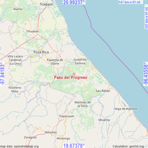
Paso del Progreso GPS coordinates[2]
20° 20' 4.128" North, 97° 8' 19.32" West
| Map corner | latitude | longitude |
|---|---|---|
| Upper-left | 20.99237°, | -97.84183° |
| Center: | 20.33448°, | -97.1387° |
| Lower-right: | 19.67378°, | -96.43558° |
| Map W x H: | 146.6×146.6 km | = 91.1×91.1mi |
| max Lat: | 32.7° ⇑35.8% North |
| Paso del Progreso: | 20.33448° |
| min Lat: | ⇓64.2% South 14.53588° |
| min Long | Paso del Progre | max Long |
| -117.105° | -97.1387° | -86.73105° |
| W 73.1%⇐ | ⇒26.9% E |
Elevation
Elevation of Paso del Progreso is 44 m = 144 ft, and this is 1209.7 m = 3969 ft below average elevation for this country.
| Max E: |
3497 m = 11473 ft | 85% |
| Avg. | 1253.7 m = 4113 ft | |
| Paso del Progreso | 44 m = 144 ft | |
Min E: |
-1 m = -3 ft | 15% |
See also: Mexico elevation on elevation.city.
Geographical zone
Paso del Progreso is located in North Torrid zone (between Equator and Tropic of Cancer). Distance of this Northern Tropic circle is 344.9 km =214.3 mi to North.| Distance of | km | miles | from Paso del Progreso |
|---|---|---|---|
| North Pole | 7746.1 | 4813.2 | to North |
| Arctic Circle | 5140.2 | 3194 | to North |
| Tropic Cancer | 344.9 | 214.3 | to North |
| Equator | 2261 | 1404.9 | to South |


Nearby cities:
15 places around Paso del Progreso: (largest is in red/bold)
• Anclón y Arenal
11.4 km =7.1 mi,  11°
11°
• Carrillo Puerto
10.3 km =6.4 mi,  335°
335°
• Cañada Rica
4.5 km =2.8 mi,  116°
116°
• Cinco de Mayo
2.8 km =1.7 mi,  159°
159°
• El Remolino
9.8 km =6.1 mi,  308°
308°
• Emiliano Zapata
7 km =4.3 mi,  316°
316°
• Francisco I. Madero
4.2 km =2.6 mi,  237°
237°
• Ignacio Allende
6.4 km =4 mi,  249°
249°
• Ignacio M. Altamirano (Plan de Altamirano)
5.9 km =3.7 mi, 6°
• La Isla
11.6 km =7.2 mi,  275°
275°
• Llanos de San Lorenzo
6.8 km =4.2 mi,  172°
172°
• Lomas de Arena
8.7 km =5.4 mi, 344°
• Montana de Zaragoza
4.2 km =2.6 mi,  293°
293°
• Rafael Rosas
4.3 km =2.7 mi, 276°
• Rafael Valenzuela
8 km =5 mi, 8°
Sources, notices
• [Note1] Compared only with cities in Mexico existing in our database
• [Src1] Map data: © OpenStreetMap contributors (CC-BY-SA)
• [Src2] Other city data from geonames.org with taken over terms of usage.
• [Src3] Geographical zone / Annual Mean Temperature by Robert A. Rohde @ Wikipedia
