Cinco de Mayo geodata
Cinco de Mayo (Veracruz) is a populated place; located in Mexico in America/Mexico_City (GMT-6) time zone. With population of 597 people, there are 14400 cities with bigger population in this country. Compared to other cities in Mexico, 63.7% of cities are located further ↓South; 73.2% of cities are located further ←West and 78.1% of cities have higher elevation than Cinco de Mayo. Note1


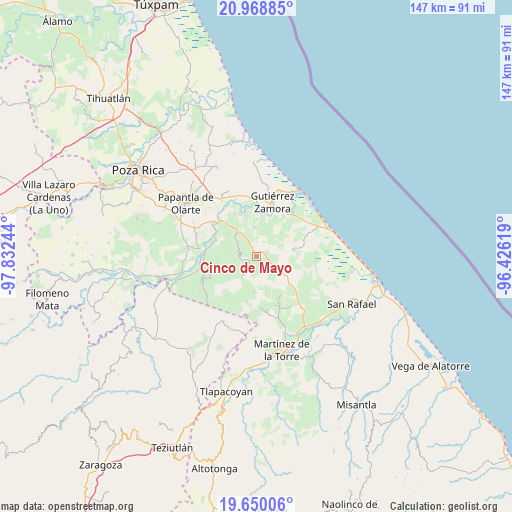
Cinco de Mayo GPS coordinates[2]
20° 18' 39.096" North, 97° 7' 45.516" West
| Map corner | latitude | longitude |
|---|---|---|
| Upper-left | 20.96885°, | -97.83244° |
| Center: | 20.31086°, | -97.12931° |
| Lower-right: | 19.65006°, | -96.42619° |
| Map W x H: | 146.6×146.6 km | = 91.1×91.1mi |
| max Lat: | 32.7° ⇑36.3% North |
| Cinco de Mayo: | 20.31086° |
| min Lat: | ⇓63.7% South 14.53588° |
| min Long | Cinco de Mayo | max Long |
| -117.105° | -97.12931° | -86.73105° |
| W 73.2%⇐ | ⇒26.8% E |
Elevation
Elevation of Cinco de Mayo is 129 m = 423 ft, and this is 1124.7 m = 3690 ft below average elevation for this country.
| Max E: |
3497 m = 11473 ft | 78.1% |
| Avg. | 1253.7 m = 4113 ft | |
| Cinco de Mayo | 129 m = 423 ft | |
Min E: |
-1 m = -3 ft | 21.9% |
See also: Mexico elevation on elevation.city.
Geographical zone
Cinco de Mayo is located in North Torrid zone (between Equator and Tropic of Cancer). Distance of this Northern Tropic circle is 347.6 km =216 mi to North.| Distance of | km | miles | from Cinco de Mayo |
|---|---|---|---|
| North Pole | 7748.7 | 4814.8 | to North |
| Arctic Circle | 5142.8 | 3195.6 | to North |
| Tropic Cancer | 347.6 | 216 | to North |
| Equator | 2258.4 | 1403.3 | to South |


Nearby cities:
15 places around Cinco de Mayo: (largest is in red/bold)
• Balsas de Agua
9.1 km =5.7 mi,  175°
175°
• Cañada Rica
3.1 km =1.9 mi,  78°
78°
• El Remolino
12.3 km =7.6 mi,  315°
315°
• Emiliano Zapata
9.6 km =6 mi, 323°
• Francisco I. Madero
4.5 km =2.8 mi,  274°
274°
• Hueytepec
10.8 km =6.7 mi, 80°
• Ignacio Allende
7 km =4.3 mi, 273°
• Ignacio M. Altamirano (Plan de Altamirano)
8.5 km =5.3 mi,  357°
357°
• Llanos de San Lorenzo
4.1 km =2.5 mi, 181°
• Lomas de Arena
11.5 km =7.1 mi,  343°
343°
• Mesa Chica la Gloria
10.1 km =6.3 mi, 183°
• Montana de Zaragoza
6.5 km =4 mi,  311°
311°
• Paso del Progreso
2.8 km =1.7 mi, 339°
• Rafael Rosas
6.1 km =3.8 mi,  300°
300°
• Rafael Valenzuela
10.5 km =6.5 mi,  0°
0°
Sources, notices
• [Note1] Compared only with cities in Mexico existing in our database
• [Src1] Map data: © OpenStreetMap contributors (CC-BY-SA)
• [Src2] Other city data from geonames.org with taken over terms of usage.
• [Src3] Geographical zone / Annual Mean Temperature by Robert A. Rohde @ Wikipedia
