Progreso del Majahual geodata
Progreso del Majahual (Veracruz) is a populated place; located in Mexico in America/Mexico_City (GMT-6) time zone. With population of 667 people, there are 13011 cities with bigger population in this country. Compared to other cities in Mexico, 70.4% of cities are located further ↑North; 83.5% of cities are located further ←West and 91.2% of cities have higher elevation than Progreso del Majahual. Note1
Current local time in Progreso del Majahual:
12:56 AM, WednesdayDifference from your time zone: hours


Progreso del Majahual GPS coordinates[2]
18° 40' 54.12" North, 95° 19' 25.104" West
| Map corner | latitude | longitude |
|---|---|---|
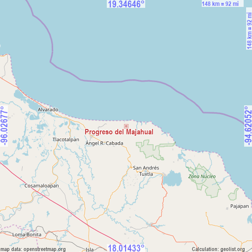
| Upper-left | 19.34646°, | -96.02677° |
| Center: | 18.6817°, | -95.32364° |
| Lower-right: | 18.01433°, | -94.62052° |
| Map W x H: | 148.1×148.1 km | = 92×92mi |
| max Lat: | 32.7° ⇑70.4% North |
| Progreso del Majahual: | 18.6817° |
| min Lat: | ⇓29.6% South 14.53588° |
| min Long | Progreso del Ma | max Long |
| -117.105° | -95.32364° | -86.73105° |
| W 83.5%⇐ | ⇒16.5% E |
Elevation
Elevation of Progreso del Majahual is 21 m = 69 ft, and this is 1232.7 m = 4044 ft below average elevation for this country.
| Max E: |
3497 m = 11473 ft | 91.2% |
| Avg. | 1253.7 m = 4113 ft | |
| Progreso del Majahual | 21 m = 69 ft | |
Min E: |
-1 m = -3 ft | 8.8% |
See also: Mexico elevation on elevation.city.
Geographical zone
Progreso del Majahual is located in North Torrid zone (between Equator and Tropic of Cancer). Distance of this Northern Tropic circle is 528.7 km =328.5 mi to North.| Distance of | km | miles | from Progreso del Majahual |
|---|---|---|---|
| North Pole | 7929.9 | 4927.4 | to North |
| Arctic Circle | 5324 | 3308.2 | to North |
| Tropic Cancer | 528.7 | 328.5 | to North |
| Equator | 2077.2 | 1290.7 | to South |


Nearby cities:
15 places around Progreso del Majahual: (largest is in red/bold)
• Brazo de la Palma (El Rincón Caliente)
10 km =6.2 mi,  229°
229°
• Chonegal
13.9 km =8.6 mi,  211°
211°
• Costa de Oro
15.5 km =9.6 mi,  86°
86°
• El Escobillal
15.6 km =9.7 mi,  223°
223°
• El Porvenir
3.5 km =2.2 mi,  238°
238°
• La Florida
7.9 km =4.9 mi, 220°
• La Nueva Victoria
7.5 km =4.7 mi,  112°
112°
• Laguna de Majahual
3.6 km =2.2 mi,  134°
134°
• Panatlán
4.9 km =3 mi, 239°
• Paso del Ingenio
9.7 km =6 mi, 205°
• Salinas Roca Partida
9 km =5.6 mi,  74°
74°
• Sinapan
16.7 km =10.4 mi,  168°
168°
• Tecolapan
12.5 km =7.8 mi,  187°
187°
• Tula
12 km =7.5 mi, 207°
• Ángel R. Cabada
16 km =9.9 mi, 233°
Sources, notices
• [Note1] Compared only with cities in Mexico existing in our database
• [Src1] Map data: © OpenStreetMap contributors (CC-BY-SA)
• [Src2] Other city data from geonames.org with taken over terms of usage.
• [Src3] Geographical zone / Annual Mean Temperature by Robert A. Rohde @ Wikipedia
