Buenos Aires geodata
Buenos Aires (Veracruz) is a populated place; located in Mexico in America/Mexico_City (GMT-6) time zone. With population of 1,998 people, there are 4356 cities with bigger population in this country. Compared to other cities in Mexico, 73% of cities are located further ↑North; 83.8% of cities are located further ←West and 69.6% of cities have higher elevation than Buenos Aires. Note1


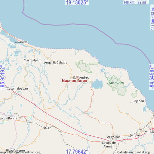
Buenos Aires GPS coordinates[2]
18° 27' 52.668" North, 95° 14' 55.644" West
| Map corner | latitude | longitude |
|---|---|---|
| Upper-left | 19.13025°, | -95.95192° |
| Center: | 18.46463°, | -95.24879° |
| Lower-right: | 17.79642°, | -94.54567° |
| Map W x H: | 148.3×148.3 km | = 92.1×92.1mi |
| max Lat: | 32.7° ⇑73% North |
| Buenos Aires: | 18.46463° |
| min Lat: | ⇓27% South 14.53588° |
| min Long | Buenos Aires | max Long |
| -117.105° | -95.24879° | -86.73105° |
| W 83.8%⇐ | ⇒16.2% E |
Elevation
Elevation of Buenos Aires is 435 m = 1427 ft, and this is 818.7 m = 2686 ft below average elevation for this country.
| Max E: |
3497 m = 11473 ft | 69.6% |
| Avg. | 1253.7 m = 4113 ft | |
| Buenos Aires | 435 m = 1427 ft | |
Min E: |
-1 m = -3 ft | 30.4% |
See also: Mexico elevation on elevation.city.
Geographical zone
Buenos Aires is located in North Torrid zone (between Equator and Tropic of Cancer). Distance of this Northern Tropic circle is 552.8 km =343.5 mi to North.| Distance of | km | miles | from Buenos Aires |
|---|---|---|---|
| North Pole | 7954 | 4942.4 | to North |
| Arctic Circle | 5348.1 | 3323.2 | to North |
| Tropic Cancer | 552.8 | 343.5 | to North |
| Equator | 2053.1 | 1275.7 | to South |


Nearby cities:
15 places around Buenos Aires: (largest is in red/bold)
• Benito Juárez
6.2 km =3.9 mi,  201°
201°
• Cerro Amarillo de Abajo
5.1 km =3.2 mi,  182°
182°
• Cerro Amarillo de Arriba
4.5 km =2.8 mi,  171°
171°
• El Polvorín
3.3 km =2.1 mi,  208°
208°
• José María Morelos y Pavón
6.4 km =4 mi,  155°
155°
• Los Pinos
2.4 km =1.5 mi, 165°
• San Andrés Tuxtla
4.1 km =2.5 mi,  115°
115°
• San Isidro Xoteapan (San Isidro Texcaltitán)
1.2 km =0.7 mi,  72°
72°
• Santiago Tuxtla
5.5 km =3.4 mi,  271°
271°
• Tetax Sesecapan
4.9 km =3 mi,  242°
242°
• Texalpan de Abajo
4.2 km =2.6 mi,  190°
190°
• Texalpan de Arriba
3.9 km =2.4 mi, 172°
• Texcaltitán Xoteapan (Texcaltitán)
2.1 km =1.3 mi, 193°
• Tonalapan
3.1 km =1.9 mi,  82°
82°
• Xoteapan
3.8 km =2.4 mi, 209°
Sources, notices
• [Note1] Compared only with cities in Mexico existing in our database
• [Src1] Map data: © OpenStreetMap contributors (CC-BY-SA)
• [Src2] Other city data from geonames.org with taken over terms of usage.
• [Src3] Geographical zone / Annual Mean Temperature by Robert A. Rohde @ Wikipedia
