Cerro Amarillo de Abajo geodata
Cerro Amarillo de Abajo (Veracruz) is a populated place; located in Mexico in America/Mexico_City (GMT-6) time zone. With population of 581 people, there are 14753 cities with bigger population in this country. Compared to other cities in Mexico, 73.5% of cities are located further ↑North; 83.8% of cities are located further ←West and 76.7% of cities have higher elevation than Cerro Amarillo de Abajo. Note1
Current local time in Cerro Amarillo de Abajo:
06:48 AM, WednesdayDifference from your time zone: hours


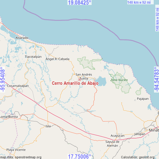
Cerro Amarillo de Abajo GPS coordinates[2]
18° 25' 6.42" North, 95° 15' 3.42" West
| Map corner | latitude | longitude |
|---|---|---|
| Upper-left | 19.08425°, | -95.95408° |
| Center: | 18.41845°, | -95.25095° |
| Lower-right: | 17.75006°, | -94.54783° |
| Map W x H: | 148.3×148.4 km | = 92.1×92.2mi |
| max Lat: | 32.7° ⇑73.5% North |
| Cerro Amarillo de Abajo: | 18.41845° |
| min Lat: | ⇓26.5% South 14.53588° |
| min Long | Cerro Amarillo | max Long |
| -117.105° | -95.25095° | -86.73105° |
| W 83.8%⇐ | ⇒16.2% E |
Elevation
Elevation of Cerro Amarillo de Abajo is 162 m = 531 ft, and this is 1091.7 m = 3582 ft below average elevation for this country.
| Max E: |
3497 m = 11473 ft | 76.7% |
| Avg. | 1253.7 m = 4113 ft | |
| Cerro Amarillo de Abajo | 162 m = 531 ft | |
Min E: |
-1 m = -3 ft | 23.3% |
See also: Mexico elevation on elevation.city.
Geographical zone
Cerro Amarillo de Abajo is located in North Torrid zone (between Equator and Tropic of Cancer). Distance of this Northern Tropic circle is 558 km =346.7 mi to North.| Distance of | km | miles | from Cerro Amarillo de Abajo |
|---|---|---|---|
| North Pole | 7959.1 | 4945.6 | to North |
| Arctic Circle | 5353.2 | 3326.3 | to North |
| Tropic Cancer | 558 | 346.7 | to North |
| Equator | 2047.9 | 1272.5 | to South |


Nearby cities:
15 places around Cerro Amarillo de Abajo: (largest is in red/bold)
• Benito Juárez
2.2 km =1.4 mi,  253°
253°
• Buenos Aires
5.1 km =3.2 mi,  2°
2°
• Cerro Amarillo de Arriba
1.1 km =0.7 mi,  54°
54°
• El Polvorín
2.6 km =1.6 mi,  328°
328°
• José María Morelos y Pavón
2.9 km =1.8 mi,  103°
103°
• Los Mérida
5 km =3.1 mi,  211°
211°
• Los Pinos
2.9 km =1.8 mi,  15°
15°
• Ocelota
4 km =2.5 mi,  237°
237°
• Ohuilapam
2.2 km =1.4 mi, 214°
• Sesecapan
5.1 km =3.2 mi,  261°
261°
• Tetax Sesecapan
5 km =3.1 mi,  304°
304°
• Texalpan de Abajo
1.1 km =0.7 mi, 331°
• Texalpan de Arriba
1.4 km =0.9 mi,  30°
30°
• Texcaltitán Xoteapan (Texcaltitán)
3.1 km =1.9 mi,  355°
355°
• Xoteapan
2.4 km =1.5 mi,  317°
317°
Sources, notices
• [Note1] Compared only with cities in Mexico existing in our database
• [Src1] Map data: © OpenStreetMap contributors (CC-BY-SA)
• [Src2] Other city data from geonames.org with taken over terms of usage.
• [Src3] Geographical zone / Annual Mean Temperature by Robert A. Rohde @ Wikipedia
