Calería geodata
Calería (Veracruz) is a populated place; located in Mexico in America/Mexico_City (GMT-6) time zone. With population of 3,910 people, there are 2337 cities with bigger population in this country. Compared to other cities in Mexico, 73.4% of cities are located further ↑North; 84% of cities are located further ←West and 74.3% of cities have higher elevation than Calería. Note1


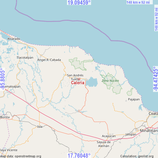
Calería GPS coordinates[2]
18° 25' 43.788" North, 95° 10' 38.532" West
| Map corner | latitude | longitude |
|---|---|---|
| Upper-left | 19.09459°, | -95.8805° |
| Center: | 18.42883°, | -95.17737° |
| Lower-right: | 17.76048°, | -94.47425° |
| Map W x H: | 148.3×148.3 km | = 92.1×92.1mi |
| max Lat: | 32.7° ⇑73.4% North |
| Calería: | 18.42883° |
| min Lat: | ⇓26.6% South 14.53588° |
| min Long | Calería | max Long |
| -117.105° | -95.17737° | -86.73105° |
| W 84%⇐ | ⇒16% E |
Elevation
Elevation of Calería is 244 m = 801 ft, and this is 1009.7 m = 3313 ft below average elevation for this country.
| Max E: |
3497 m = 11473 ft | 74.3% |
| Avg. | 1253.7 m = 4113 ft | |
| Calería | 244 m = 801 ft | |
Min E: |
-1 m = -3 ft | 25.7% |
See also: Mexico elevation on elevation.city.
Geographical zone
Calería is located in North Torrid zone (between Equator and Tropic of Cancer). Distance of this Northern Tropic circle is 556.8 km =346 mi to North.| Distance of | km | miles | from Calería |
|---|---|---|---|
| North Pole | 7958 | 4944.9 | to North |
| Arctic Circle | 5352.1 | 3325.6 | to North |
| Tropic Cancer | 556.8 | 346 | to North |
| Equator | 2049.1 | 1273.3 | to South |


Nearby cities:
15 places around Calería: (largest is in red/bold)
• Bezuapan
3 km =1.9 mi,  135°
135°
• Catemaco
6.7 km =4.2 mi,  97°
97°
• Cebadilla Chica
6.7 km =4.2 mi,  179°
179°
• Cerro Amarillo de Arriba
6.9 km =4.3 mi,  265°
265°
• Cerro las Iguanas
3.1 km =1.9 mi,  229°
229°
• Comoapan
2.5 km =1.6 mi,  172°
172°
• El Huidero
4.6 km =2.9 mi, 182°
• El Salto de Eyipantla
5.1 km =3.2 mi,  211°
211°
• José María Morelos y Pavón
5.2 km =3.2 mi,  249°
249°
• Matacapan
1.4 km =0.9 mi,  61°
61°
• San Andrés Tuxtla
4.4 km =2.7 mi,  300°
300°
• Santa Rosa Abata
3.8 km =2.4 mi,  15°
15°
• Sihuapan
0.9 km =0.6 mi,  353°
353°
• Texalpan de Arriba
7 km =4.3 mi, 270°
• Tonalapan
6.3 km =3.9 mi,  314°
314°
Sources, notices
• [Note1] Compared only with cities in Mexico existing in our database
• [Src1] Map data: © OpenStreetMap contributors (CC-BY-SA)
• [Src2] Other city data from geonames.org with taken over terms of usage.
• [Src3] Geographical zone / Annual Mean Temperature by Robert A. Rohde @ Wikipedia
