San Miguel Yuxtepec geodata
San Miguel Yuxtepec (State of Mexico) is a populated place; located in Mexico in America/Mexico_City (GMT-6) time zone. With population of 1,473 people, there are 5868 cities with bigger population in this country. Compared to other cities in Mexico, 53.3% of cities are located further ↑North; 60.4% of cities are located further →East and 97.6% of cities have lower elevation than San Miguel Yuxtepec. Note1


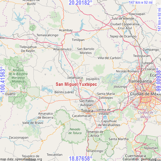
San Miguel Yuxtepec GPS coordinates[2]
19° 32' 26.016" North, 99° 42' 45" West
| Map corner | latitude | longitude |
|---|---|---|
| Upper-left | 20.20182°, | -100.41563° |
| Center: | 19.54056°, | -99.7125° |
| Lower-right: | 18.87658°, | -99.00938° |
| Map W x H: | 147.4×147.4 km | = 91.6×91.6mi |
| max Lat: | 32.7° ⇑53.3% North |
| San Miguel Yuxtepec: | 19.54056° |
| min Lat: | ⇓46.7% South 14.53588° |
| min Long | San Miguel Yuxt | max Long |
| -117.105° | -99.7125° | -86.73105° |
| W 39.6%⇐ | ⇒60.4% E |
Elevation
Elevation of San Miguel Yuxtepec is 2723 m = 8934 ft, and this is 1469.3 m = 4821 ft above average elevation for this country.
| Max E: |
3497 m = 11473 ft | 2.4% |
| San Miguel Yuxtepec | 2723 m 8934 ft | |
| Avg. | 1253.7 m = 4113 ft | |
Min E: |
-1 m = -3 ft | 97.6% |
See also: Mexico elevation on elevation.city.
Geographical zone
San Miguel Yuxtepec is located in North Torrid zone (between Equator and Tropic of Cancer). Distance of this Northern Tropic circle is 433.2 km =269.2 mi to North.| Distance of | km | miles | from San Miguel Yuxtepec |
|---|---|---|---|
| North Pole | 7834.4 | 4868.1 | to North |
| Arctic Circle | 5228.5 | 3248.8 | to North |
| Tropic Cancer | 433.2 | 269.2 | to North |
| Equator | 2172.7 | 1350.1 | to South |


Nearby cities:
15 places around San Miguel Yuxtepec: (largest is in red/bold)
• Barrio de San Pedro la Cabecera
4.8 km =3 mi,  304°
304°
• Colonia San Francisco de Asís
6.1 km =3.8 mi,  313°
313°
• Colonia la Purísima
5.7 km =3.5 mi,  43°
43°
• Ejido de Mañi
5.4 km =3.4 mi,  61°
61°
• Ejido la Purísima
1.8 km =1.1 mi,  326°
326°
• Loma del Astillero
6.5 km =4 mi, 39°
• Manzana Tercera de Santa Cruz Tepexpan
3.3 km =2.1 mi,  16°
16°
• Portezuelo
5.8 km =3.6 mi,  105°
105°
• San Antonio Bonixi
5.6 km =3.5 mi,  195°
195°
• San Bartolo del Llano
6.3 km =3.9 mi, 331°
• San Jerónimo Ixtapantongo
5.8 km =3.6 mi,  267°
267°
• San Lorenzo Toxico
6.3 km =3.9 mi,  236°
236°
• San Martín Morelos
3.3 km =2.1 mi, 106°
• Sección del Cerrito
4.1 km =2.5 mi, 60°
• Tierra Blanca
4.8 km =3 mi, 42°
Sources, notices
• [Note1] Compared only with cities in Mexico existing in our database
• [Src1] Map data: © OpenStreetMap contributors (CC-BY-SA)
• [Src2] Other city data from geonames.org with taken over terms of usage.
• [Src3] Geographical zone / Annual Mean Temperature by Robert A. Rohde @ Wikipedia
