San Lorenzo Toxico geodata
San Lorenzo Toxico (State of Mexico) is a populated place; located in Mexico in America/Mexico_City (GMT-6) time zone. With population of 3,302 people, there are 2754 cities with bigger population in this country. Compared to other cities in Mexico, 53.9% of cities are located further ↑North; 61% of cities are located further →East and 95.4% of cities have lower elevation than San Lorenzo Toxico. Note1


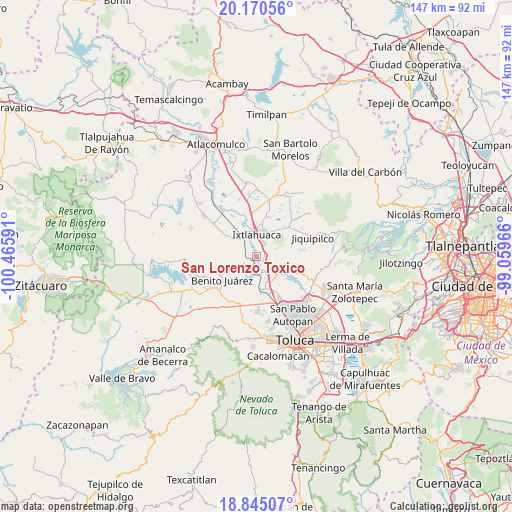
San Lorenzo Toxico GPS coordinates[2]
19° 30' 33.012" North, 99° 45' 46.008" West
| Map corner | latitude | longitude |
|---|---|---|
| Upper-left | 20.17056°, | -100.46591° |
| Center: | 19.50917°, | -99.76278° |
| Lower-right: | 18.84507°, | -99.05966° |
| Map W x H: | 147.4×147.4 km | = 91.6×91.6mi |
| max Lat: | 32.7° ⇑53.9% North |
| San Lorenzo Toxico: | 19.50917° |
| min Lat: | ⇓46.1% South 14.53588° |
| min Long | San Lorenzo Tox | max Long |
| -117.105° | -99.76278° | -86.73105° |
| W 39%⇐ | ⇒61% E |
Elevation
Elevation of San Lorenzo Toxico is 2604 m = 8543 ft, and this is 1350.3 m = 4430 ft above average elevation for this country.
| Max E: |
3497 m = 11473 ft | 4.6% |
| San Lorenzo Toxico | 2604 m 8543 ft | |
| Avg. | 1253.7 m = 4113 ft | |
Min E: |
-1 m = -3 ft | 95.4% |
See also: Mexico elevation on elevation.city.
Geographical zone
San Lorenzo Toxico is located in North Torrid zone (between Equator and Tropic of Cancer). Distance of this Northern Tropic circle is 436.7 km =271.4 mi to North.| Distance of | km | miles | from San Lorenzo Toxico |
|---|---|---|---|
| North Pole | 7837.8 | 4870.2 | to North |
| Arctic Circle | 5232 | 3251 | to North |
| Tropic Cancer | 436.7 | 271.4 | to North |
| Equator | 2169.2 | 1347.9 | to South |


Nearby cities:
15 places around San Lorenzo Toxico: (largest is in red/bold)
• Barrio San Joaquín el Junco
6.2 km =3.9 mi,  349°
349°
• Barrio de San Pedro la Cabecera
6.4 km =4 mi,  12°
12°
• Barrio del Carmen
7.3 km =4.5 mi,  208°
208°
• Colonia San Francisco de Asís
7.8 km =4.8 mi, 6°
• Ejido la Purísima
6.6 km =4.1 mi,  40°
40°
• El Rincón de los Perales
7.8 km =4.8 mi,  298°
298°
• Ixtlahuaca de Rayón
6.7 km =4.2 mi,  356°
356°
• Mayorazgo de León
4.9 km =3 mi,  155°
155°
• San Agustín Citlali
5.2 km =3.2 mi,  232°
232°
• San Antonio Atotonilco
5.2 km =3.2 mi,  197°
197°
• San Antonio Bonixi
4.2 km =2.6 mi,  116°
116°
• San Ildefonso
6.3 km =3.9 mi,  337°
337°
• San Jerónimo Ixtapantongo
3.3 km =2.1 mi, 350°
• San Miguel Yuxtepec
6.3 km =3.9 mi,  56°
56°
• Santa Juana Segunda Sección
6.2 km =3.9 mi,  146°
146°
Sources, notices
• [Note1] Compared only with cities in Mexico existing in our database
• [Src1] Map data: © OpenStreetMap contributors (CC-BY-SA)
• [Src2] Other city data from geonames.org with taken over terms of usage.
• [Src3] Geographical zone / Annual Mean Temperature by Robert A. Rohde @ Wikipedia
