San Sebastián geodata
San Sebastián (Morelos) is a populated place; located in Mexico in America/Mexico_City (GMT-6) time zone. With population of 2,017 people, there are 4310 cities with bigger population in this country. Compared to other cities in Mexico, 60.3% of cities are located further ↑North; 57.5% of cities are located further →East and 94.4% of cities have lower elevation than San Sebastián. Note1


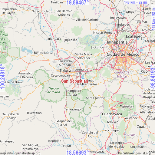
San Sebastián GPS coordinates[2]
19° 13' 55.704" North, 99° 32' 42.18" West
| Map corner | latitude | longitude |
|---|---|---|
| Upper-left | 19.89467°, | -100.24818° |
| Center: | 19.23214°, | -99.54505° |
| Lower-right: | 18.56693°, | -98.84193° |
| Map W x H: | 147.6×147.6 km | = 91.7×91.7mi |
| max Lat: | 32.7° ⇑60.3% North |
| San Sebastián: | 19.23214° |
| min Lat: | ⇓39.7% South 14.53588° |
| min Long | San Sebastián | max Long |
| -117.105° | -99.54505° | -86.73105° |
| W 42.5%⇐ | ⇒57.5% E |
Elevation
Elevation of San Sebastián is 2582 m = 8471 ft, and this is 1328.3 m = 4358 ft above average elevation for this country.
| Max E: |
3497 m = 11473 ft | 5.6% |
| San Sebastián | 2582 m 8471 ft | |
| Avg. | 1253.7 m = 4113 ft | |
Min E: |
-1 m = -3 ft | 94.4% |
See also: Mexico elevation on elevation.city.
Geographical zone
San Sebastián is located in North Torrid zone (between Equator and Tropic of Cancer). Distance of this Northern Tropic circle is 467.5 km =290.5 mi to North.| Distance of | km | miles | from San Sebastián |
|---|---|---|---|
| North Pole | 7868.6 | 4889.3 | to North |
| Arctic Circle | 5262.8 | 3270.2 | to North |
| Tropic Cancer | 467.5 | 290.5 | to North |
| Equator | 2138.4 | 1328.7 | to South |


Nearby cities:
15 places around San Sebastián: (largest is in red/bold)
• Atizapán
2.1 km =1.3 mi,  345°
345°
• Barrio de la Asunción
4 km =2.5 mi,  264°
264°
• Chapultepec
3.8 km =2.4 mi,  207°
207°
• Colonia Agrícola Álvaro Obregón
1.2 km =0.7 mi,  248°
248°
• Colonia Arboledas (San Andrés)
5 km =3.1 mi,  228°
228°
• Colonia Llano Grande (El Salitre)
2.4 km =1.5 mi,  306°
306°
• Colonia la Presa (Ejido de Chapultepec)
3.5 km =2.2 mi,  179°
179°
• Mexicaltzingo
4.8 km =3 mi,  240°
240°
• San Bartolito Tlaltelolco
4.8 km =3 mi,  200°
200°
• San Gaspar Tlahuelilpan
1.2 km =0.7 mi,  356°
356°
• San Mateo Atenco
4.2 km =2.6 mi,  18°
18°
• San Miguel Totocuitlapilco
5.2 km =3.2 mi,  265°
265°
• San Pedro Tultepec
5.2 km =3.2 mi,  45°
45°
• Santa María la Asunción
4 km =2.5 mi, 348°
• Unidad Habitacional Santa Teresa
1.9 km =1.2 mi, 202°
Sources, notices
• [Note1] Compared only with cities in Mexico existing in our database
• [Src1] Map data: © OpenStreetMap contributors (CC-BY-SA)
• [Src2] Other city data from geonames.org with taken over terms of usage.
• [Src3] Geographical zone / Annual Mean Temperature by Robert A. Rohde @ Wikipedia
