Antonio Rosales geodata
Antonio Rosales (Sonora) is a populated place; located in Mexico in America/Hermosillo (GMT-7) time zone. With population of 1,006 people, there are 8667 cities with bigger population in this country. Compared to other cities in Mexico, 97.3% of cities are located further ↓South; 98.4% of cities are located further →East and 82.9% of cities have higher elevation than Antonio Rosales. Note1


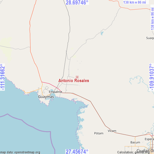
Antonio Rosales GPS coordinates[2]
28° 4' 44.004" North, 110° 36' 48.564" West
| Map corner | latitude | longitude |
|---|---|---|
| Upper-left | 28.69746°, | -111.31662° |
| Center: | 28.07889°, | -110.61349° |
| Lower-right: | 27.45674°, | -109.91037° |
| Map W x H: | 138×138 km | = 85.7×85.7mi |
| max Lat: | 32.7° ⇑2.7% North |
| Antonio Rosales: | 28.07889° |
| min Lat: | ⇓97.3% South 14.53588° |
| min Long | Antonio Rosales | max Long |
| -117.105° | -110.61349° | -86.73105° |
| W 1.6%⇐ | ⇒98.4% E |
Elevation
Elevation of Antonio Rosales is 61 m = 200 ft, and this is 1192.7 m = 3913 ft below average elevation for this country.
| Max E: |
3497 m = 11473 ft | 82.9% |
| Avg. | 1253.7 m = 4113 ft | |
| Antonio Rosales | 61 m = 200 ft | |
Min E: |
-1 m = -3 ft | 17.1% |
See also: Mexico elevation on elevation.city.
Geographical zone
Antonio Rosales is located in North temperate zone (between Tropic of Cancer and the Arctic Circle). Distance of this Northern Tropic circle is 516.2 km =320.8 mi to South.| Distance of | km | miles | from Antonio Rosales |
|---|---|---|---|
| North Pole | 6885 | 4278.1 | to North |
| Arctic Circle | 4279.1 | 2658.9 | to North |
| Tropic Cancer | 516.2 | 320.8 | to South |
| Equator | 3122.1 | 1940 | to South |


Nearby cities:
15 places around Antonio Rosales: (largest is in red/bold)
• Cruz de Piedra
15.5 km =9.6 mi,  203°
203°
• Empalme
23.6 km =14.7 mi,  236°
236°
• Francisco Márquez
9.1 km =5.7 mi,  13°
13°
• Guásimas (De Belem)
21.7 km =13.5 mi,  171°
171°
• Heroica Guaymas
33.1 km =20.6 mi, 237°
• José María Morelos y Pavón
7.8 km =4.8 mi,  285°
285°
• La Palma
9.2 km =5.7 mi,  249°
249°
• Maytorena
13.1 km =8.1 mi,  268°
268°
• Mi Patria es Primero
7 km =4.3 mi, 244°
• Ortiz
25.2 km =15.7 mi,  337°
337°
• San Carlos
44.3 km =27.5 mi, 252°
• San Fernando de Guaymas
15.3 km =9.5 mi,  219°
219°
• San José de Guaymas
28.2 km =17.5 mi, 248°
• Santa María de Guaymas
10.5 km =6.5 mi,  312°
312°
• Ursulo Galván
7.1 km =4.4 mi, 271°
Sources, notices
• [Note1] Compared only with cities in Mexico existing in our database
• [Src1] Map data: © OpenStreetMap contributors (CC-BY-SA)
• [Src2] Other city data from geonames.org with taken over terms of usage.
• [Src3] Geographical zone / Annual Mean Temperature by Robert A. Rohde @ Wikipedia
