El Serranito geodata
El Serranito (Sinaloa) is a populated place; located in Mexico in America/Mazatlan (GMT-7) time zone. With population of 553 people, there are 15422 cities with bigger population in this country. Compared to other cities in Mexico, 92.9% of cities are located further ↓South; 95.8% of cities are located further →East and 86.5% of cities have higher elevation than El Serranito. Note1


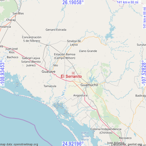
El Serranito GPS coordinates[2]
25° 33' 28.62" North, 108° 13' 53.04" West
| Map corner | latitude | longitude |
|---|---|---|
| Upper-left | 26.19058°, | -108.93453° |
| Center: | 25.55795°, | -108.2314° |
| Lower-right: | 24.92196°, | -107.52828° |
| Map W x H: | 141.1×141.1 km | = 87.7×87.7mi |
| max Lat: | 32.7° ⇑7.1% North |
| El Serranito: | 25.55795° |
| min Lat: | ⇓92.9% South 14.53588° |
| min Long | El Serranito | max Long |
| -117.105° | -108.2314° | -86.73105° |
| W 4.2%⇐ | ⇒95.8% E |
Elevation
Elevation of El Serranito is 36 m = 118 ft, and this is 1217.7 m = 3995 ft below average elevation for this country.
| Max E: |
3497 m = 11473 ft | 86.5% |
| Avg. | 1253.7 m = 4113 ft | |
| El Serranito | 36 m = 118 ft | |
Min E: |
-1 m = -3 ft | 13.5% |
See also: Mexico elevation on elevation.city.
Geographical zone
El Serranito is located in North temperate zone (between Tropic of Cancer and the Arctic Circle). Distance of this Northern Tropic circle is 235.9 km =146.6 mi to South.| Distance of | km | miles | from El Serranito |
|---|---|---|---|
| North Pole | 7165.3 | 4452.3 | to North |
| Arctic Circle | 4559.4 | 2833.1 | to North |
| Tropic Cancer | 235.9 | 146.6 | to South |
| Equator | 2841.8 | 1765.8 | to South |


Nearby cities:
15 places around El Serranito: (largest is in red/bold)
• Alfredo V. Bonfil (Siete Ejidos)
9.5 km =5.9 mi,  358°
358°
• Choipa
11.1 km =6.9 mi,  313°
313°
• Cruz Blanca
12.7 km =7.9 mi,  199°
199°
• El Coyote
12.9 km =8 mi, 355°
• El Platanito
8.4 km =5.2 mi,  264°
264°
• Estación Capomas
4.8 km =3 mi,  9°
9°
• Francisco R. Serrano
2.9 km =1.8 mi,  150°
150°
• Gabriel Leyva Velázquez (La Escalera)
12.6 km =7.8 mi,  164°
164°
• Herculano de la Rocha
11 km =6.8 mi, 314°
• La Pichihuila
7.5 km =4.7 mi,  254°
254°
• Las Américas
8.5 km =5.3 mi,  291°
291°
• Las Brisas
7.7 km =4.8 mi,  190°
190°
• Norotillos
13.3 km =8.3 mi,  321°
321°
• San Rafael
10.3 km =6.4 mi,  226°
226°
• Terahuito
9 km =5.6 mi,  265°
265°
Sources, notices
• [Note1] Compared only with cities in Mexico existing in our database
• [Src1] Map data: © OpenStreetMap contributors (CC-BY-SA)
• [Src2] Other city data from geonames.org with taken over terms of usage.
• [Src3] Geographical zone / Annual Mean Temperature by Robert A. Rohde @ Wikipedia
