Terahuito geodata
Terahuito (Sinaloa) is a populated place; located in Mexico in America/Mazatlan (GMT-7) time zone. With population of 978 people, there are 8889 cities with bigger population in this country. Compared to other cities in Mexico, 92.9% of cities are located further ↓South; 96% of cities are located further →East and 90.4% of cities have higher elevation than Terahuito. Note1


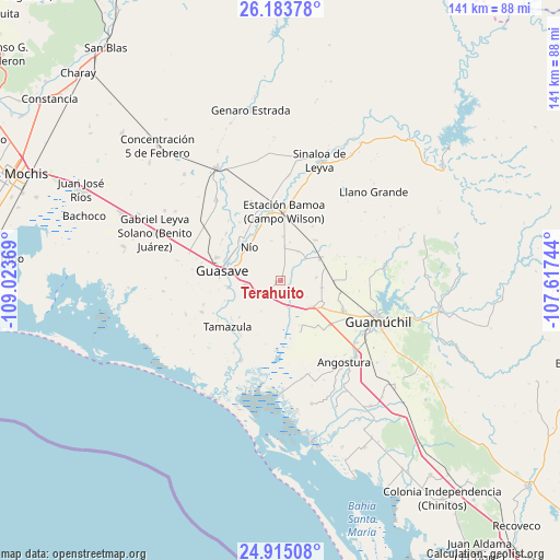
Terahuito GPS coordinates[2]
25° 33' 3.996" North, 108° 19' 14.016" West
| Map corner | latitude | longitude |
|---|---|---|
| Upper-left | 26.18378°, | -109.02369° |
| Center: | 25.55111°, | -108.32056° |
| Lower-right: | 24.91508°, | -107.61744° |
| Map W x H: | 141.1×141.1 km | = 87.7×87.7mi |
| max Lat: | 32.7° ⇑7.1% North |
| Terahuito: | 25.55111° |
| min Lat: | ⇓92.9% South 14.53588° |
| min Long | Terahuito | max Long |
| -117.105° | -108.32056° | -86.73105° |
| W 4%⇐ | ⇒96% E |
Elevation
Elevation of Terahuito is 23 m = 75 ft, and this is 1230.7 m = 4038 ft below average elevation for this country.
| Max E: |
3497 m = 11473 ft | 90.4% |
| Avg. | 1253.7 m = 4113 ft | |
| Terahuito | 23 m = 75 ft | |
Min E: |
-1 m = -3 ft | 9.6% |
See also: Mexico elevation on elevation.city.
Geographical zone
Terahuito is located in North temperate zone (between Tropic of Cancer and the Arctic Circle). Distance of this Northern Tropic circle is 235.1 km =146.1 mi to South.| Distance of | km | miles | from Terahuito |
|---|---|---|---|
| North Pole | 7166 | 4452.7 | to North |
| Arctic Circle | 4560.2 | 2833.6 | to North |
| Tropic Cancer | 235.1 | 146.1 | to South |
| Equator | 2841 | 1765.3 | to South |


Nearby cities:
15 places around Terahuito: (largest is in red/bold)
• Choipa
8.4 km =5.2 mi,  5°
5°
• El Burrión
9.4 km =5.8 mi,  261°
261°
• El Platanito
0.6 km =0.4 mi,  95°
95°
• El Serranito
9 km =5.6 mi,  85°
85°
• Francisco R. Serrano
10.6 km =6.6 mi, 99°
• Herculano de la Rocha
8.5 km =5.3 mi, 7°
• Javier Rojo Gómez
8.5 km =5.3 mi,  222°
222°
• La Pichihuila
2.1 km =1.3 mi,  126°
126°
• Las Américas
4.1 km =2.5 mi, 14°
• Las Brisas
10.1 km =6.3 mi, 132°
• Norotillos
11.1 km =6.9 mi,  3°
3°
• Pitahayal
10.1 km =6.3 mi,  208°
208°
• Ranchito de Castro
10.5 km =6.5 mi,  292°
292°
• San Rafael
6.5 km =4 mi,  166°
166°
• Vicente Guerrero
9.2 km =5.7 mi, 212°
Sources, notices
• [Note1] Compared only with cities in Mexico existing in our database
• [Src1] Map data: © OpenStreetMap contributors (CC-BY-SA)
• [Src2] Other city data from geonames.org with taken over terms of usage.
• [Src3] Geographical zone / Annual Mean Temperature by Robert A. Rohde @ Wikipedia
