Primo Tapia geodata
Primo Tapia (Baja California) is a populated place; located in Mexico in America/Tijuana (GMT-7) time zone. With population of 4,921 people, there are 1878 cities with bigger population in this country. Compared to other cities in Mexico, 99.3% of cities are located further ↓South; 99.8% of cities are located further →East and 82.8% of cities have higher elevation than Primo Tapia. Note1


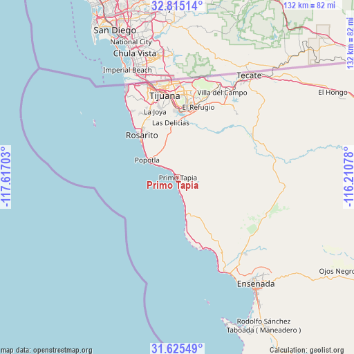
Primo Tapia GPS coordinates[2]
32° 13' 20.136" North, 116° 54' 50.04" West
| Map corner | latitude | longitude |
|---|---|---|
| Upper-left | 32.81514°, | -117.61703° |
| Center: | 32.22226°, | -116.9139° |
| Lower-right: | 31.62549°, | -116.21078° |
| Map W x H: | 132.3×132.3 km | = 82.2×82.2mi |
| max Lat: | 32.7° ⇑0.7% North |
| Primo Tapia: | 32.22226° |
| min Lat: | ⇓99.3% South 14.53588° |
| min Long | Primo Tapia | max Long |
| -117.105° | -116.9139° | -86.73105° |
| W 0.2%⇐ | ⇒99.8% E |
Elevation
Elevation of Primo Tapia is 62 m = 203 ft, and this is 1191.7 m = 3910 ft below average elevation for this country.
| Max E: |
3497 m = 11473 ft | 82.8% |
| Avg. | 1253.7 m = 4113 ft | |
| Primo Tapia | 62 m = 203 ft | |
Min E: |
-1 m = -3 ft | 17.2% |
See also: Mexico elevation on elevation.city.
Geographical zone
Primo Tapia is located in North temperate zone (between Tropic of Cancer and the Arctic Circle). Distance of this Northern Tropic circle is 976.9 km =607 mi to South.| Distance of | km | miles | from Primo Tapia |
|---|---|---|---|
| North Pole | 6424.3 | 3991.9 | to North |
| Arctic Circle | 3818.4 | 2372.6 | to North |
| Tropic Cancer | 976.9 | 607 | to South |
| Equator | 3582.8 | 2226.2 | to South |


Nearby cities:
15 places around Primo Tapia: (largest is in red/bold)
• Buenos Aires
22.4 km =13.9 mi,  353°
353°
• Ciudad Morelos
16.3 km =10.1 mi,  326°
326°
• Colinas del Sol
22.9 km =14.2 mi, 331°
• El Descanso
3.3 km =2.1 mi,  138°
138°
• Ladrillera Pescador
3.7 km =2.3 mi, 326°
• Las Delicias
20.9 km =13 mi, 352°
• Los Valles
19.3 km =12 mi, 348°
• Los Volcanes
13.9 km =8.6 mi,  321°
321°
• Misión del Mar 1ra. y 2da. Sección
13.6 km =8.5 mi,  310°
310°
• Rosarito
19.8 km =12.3 mi, 320°
• Santa Anita
14.1 km =8.8 mi,  162°
162°
• Valle Bonito
22.8 km =14.2 mi,  7°
7°
• Venustiano Carranza
6.4 km =4 mi,  167°
167°
• Villa del Prado 2da Sección
23.1 km =14.4 mi, 346°
• Vista Marina
4.2 km =2.6 mi, 324°
Sources, notices
• [Note1] Compared only with cities in Mexico existing in our database
• [Src1] Map data: © OpenStreetMap contributors (CC-BY-SA)
• [Src2] Other city data from geonames.org with taken over terms of usage.
• [Src3] Geographical zone / Annual Mean Temperature by Robert A. Rohde @ Wikipedia
