Santa Isabel geodata
Santa Isabel (Baja California) is a populated place; located in Mexico in America/Tijuana (GMT-7) time zone. With population of 29,311 people, there are 340 cities with bigger population in this country. Compared to other cities in Mexico, 100% of cities are located further ↓South; 99.5% of cities are located further →East and 100% of cities have higher elevation than Santa Isabel. Note1


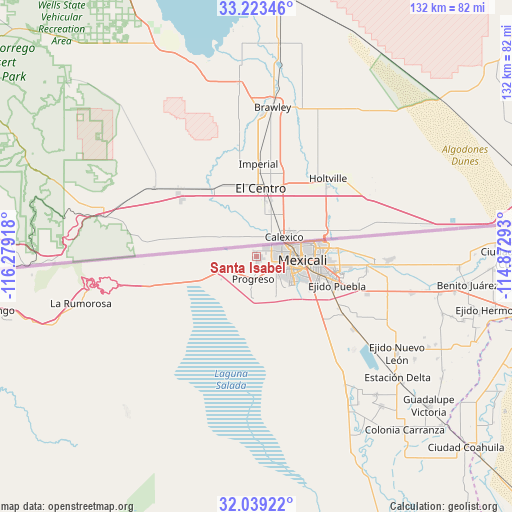
Santa Isabel GPS coordinates[2]
32° 37' 59.88" North, 115° 34' 33.78" West
| Map corner | latitude | longitude |
|---|---|---|
| Upper-left | 33.22346°, | -116.27918° |
| Center: | 32.6333°, | -115.57605° |
| Lower-right: | 32.03922°, | -114.87293° |
| Map W x H: | 131.7×131.7 km | = 81.8×81.8mi |
| max Lat: | 32.7° ⇑0% North |
| Santa Isabel: | 32.6333° |
| min Lat: | ⇓100% South 14.53588° |
| min Long | Santa Isabel | max Long |
| -117.105° | -115.57605° | -86.73105° |
| W 0.5%⇐ | ⇒99.5% E |
Elevation
Elevation of Santa Isabel is -1 m = -3 ft, and this is 1254.7 m = 4116 ft below average elevation for this country.
| Max E: |
3497 m = 11473 ft | 100% |
| Avg. | 1253.7 m = 4113 ft | |
| Santa Isabel | -1 m = -3 ft | |
Min E: |
-1 m = -3 ft | 0% |
See also: Mexico elevation on elevation.city.
Geographical zone
Santa Isabel is located in North temperate zone (between Tropic of Cancer and the Arctic Circle). Distance of this Northern Tropic circle is 1022.6 km =635.4 mi to South.| Distance of | km | miles | from Santa Isabel |
|---|---|---|---|
| North Pole | 6378.6 | 3963.5 | to North |
| Arctic Circle | 3772.7 | 2344.2 | to North |
| Tropic Cancer | 1022.6 | 635.4 | to South |
| Equator | 3628.5 | 2254.6 | to South |


Nearby cities:
15 places around Santa Isabel: (largest is in red/bold)
• Ejido Michoacán de Ocampo
31.2 km =19.4 mi,  126°
126°
• Ejido Sinaloa
30.2 km =18.8 mi,  108°
108°
• Ejido Tamaulipas
33.6 km =20.9 mi, 106°
• Ejido el Choropo (Colonia Colorado Número Uno)
19.1 km =11.9 mi, 127°
• Guanajuato
25.7 km =16 mi,  119°
119°
• Islas Agrarias Grupo A
23 km =14.3 mi,  96°
96°
• Islas Agrarias Grupo B
28.7 km =17.8 mi, 97°
• Jesús Sansón Flores
28.5 km =17.7 mi,  138°
138°
• Lomas de Abasolo
19.8 km =12.3 mi,  93°
93°
• Mexicali
11.4 km =7.1 mi, 93°
• Progreso
5.9 km =3.7 mi,  187°
187°
• Puebla
22.1 km =13.7 mi, 109°
• Reacomodo Río Colorado
5.8 km =3.6 mi, 126°
• Viñas del Sol
2.8 km =1.7 mi, 104°
• Zaragoza
5.3 km =3.3 mi, 130°
Sources, notices
• [Note1] Compared only with cities in Mexico existing in our database
• [Src1] Map data: © OpenStreetMap contributors (CC-BY-SA)
• [Src2] Other city data from geonames.org with taken over terms of usage.
• [Src3] Geographical zone / Annual Mean Temperature by Robert A. Rohde @ Wikipedia
