Delta geodata
Delta (Baja California) is a populated place; located in Mexico in America/Tijuana (GMT-7) time zone. With population of 5,180 people, there are 1792 cities with bigger population in this country. Compared to other cities in Mexico, 99.4% of cities are located further ↓South; 99.3% of cities are located further →East and 96.3% of cities have higher elevation than Delta. Note1


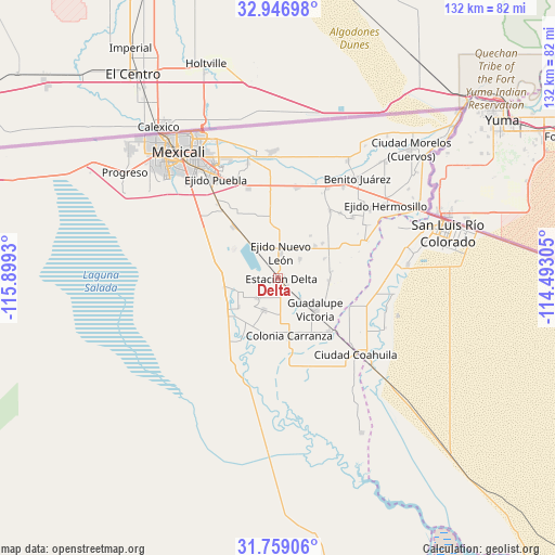
Delta GPS coordinates[2]
32° 21' 17.892" North, 115° 11' 46.212" West
| Map corner | latitude | longitude |
|---|---|---|
| Upper-left | 32.94698°, | -115.8993° |
| Center: | 32.35497°, | -115.19617° |
| Lower-right: | 31.75906°, | -114.49305° |
| Map W x H: | 132.1×132.1 km | = 82.1×82.1mi |
| max Lat: | 32.7° ⇑0.6% North |
| Delta: | 32.35497° |
| min Lat: | ⇓99.4% South 14.53588° |
| min Long | Delta | max Long |
| -117.105° | -115.19617° | -86.73105° |
| W 0.7%⇐ | ⇒99.3% E |
Elevation
Elevation of Delta is 11 m = 36 ft, and this is 1242.7 m = 4077 ft below average elevation for this country.
| Max E: |
3497 m = 11473 ft | 96.3% |
| Avg. | 1253.7 m = 4113 ft | |
| Delta | 11 m = 36 ft | |
Min E: |
-1 m = -3 ft | 3.7% |
See also: Mexico elevation on elevation.city.
Geographical zone
Delta is located in North temperate zone (between Tropic of Cancer and the Arctic Circle). Distance of this Northern Tropic circle is 991.6 km =616.2 mi to South.| Distance of | km | miles | from Delta |
|---|---|---|---|
| North Pole | 6409.5 | 3982.7 | to North |
| Arctic Circle | 3803.6 | 2363.4 | to North |
| Tropic Cancer | 991.6 | 616.2 | to South |
| Equator | 3597.5 | 2235.4 | to South |


Nearby cities:
15 places around Delta: (largest is in red/bold)
• Colonia La Puerta
12.9 km =8 mi,  257°
257°
• Colonia Venustiano Carranza
13.4 km =8.3 mi,  168°
168°
• Durango
12.9 km =8 mi,  204°
204°
• Ejido Jalapa
12.4 km =7.7 mi,  359°
359°
• Ejido Nuevo León
6.3 km =3.9 mi,  6°
6°
• Ejido Pátzcuaro
12.2 km =7.6 mi,  91°
91°
• Ejido Saltillo
10.2 km =6.3 mi,  40°
40°
• Ejido Sonora
8.2 km =5.1 mi, 203°
• Ejido Tlaxcala
12.8 km =8 mi, 37°
• Ejido Toluca
13.5 km =8.4 mi,  51°
51°
• Ejido Vicente Guerrero
7 km =4.3 mi, 49°
• Estación Pescaderos
7.2 km =4.5 mi,  131°
131°
• Guadalupe Victoria
11.2 km =7 mi, 130°
• Poblado Alfredo V. Bonfil
12.1 km =7.5 mi,  96°
96°
• Poblado Lázaro Cárdenas (La Veintiocho)
12.5 km =7.8 mi,  80°
80°
Sources, notices
• [Note1] Compared only with cities in Mexico existing in our database
• [Src1] Map data: © OpenStreetMap contributors (CC-BY-SA)
• [Src2] Other city data from geonames.org with taken over terms of usage.
• [Src3] Geographical zone / Annual Mean Temperature by Robert A. Rohde @ Wikipedia
