Sombrerete geodata
Sombrerete (Zacatecas) is a seat of a second-order administrative division; located in Mexico in America/Mexico_City (GMT-6) time zone. With population of 21,702 people, there are 474 cities with bigger population in this country. Compared to other cities in Mexico, 89.2% of cities are located further ↓South; 88.8% of cities are located further →East and 86.8% of cities have lower elevation than Sombrerete. Note1


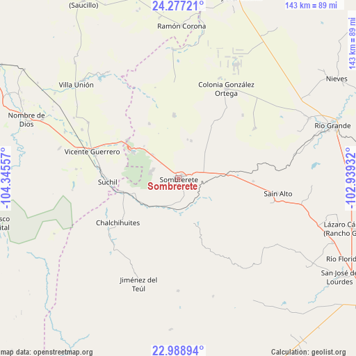
Sombrerete GPS coordinates[2]
23° 38' 4.776" North, 103° 38' 32.784" West
| Map corner | latitude | longitude |
|---|---|---|
| Upper-left | 24.27721°, | -104.34557° |
| Center: | 23.63466°, | -103.64244° |
| Lower-right: | 22.98894°, | -102.93932° |
| Map W x H: | 143.2×143.2 km | = 89×89mi |
| max Lat: | 32.7° ⇑10.8% North |
| Sombrerete: | 23.63466° |
| min Lat: | ⇓89.2% South 14.53588° |
| min Long | Sombrerete | max Long |
| -117.105° | -103.64244° | -86.73105° |
| W 11.2%⇐ | ⇒88.8% E |
Elevation
Elevation of Sombrerete is 2305 m = 7562 ft, and this is 1051.3 m = 3449 ft above average elevation for this country.
| Max E: |
3497 m = 11473 ft | 13.2% |
| Sombrerete | 2305 m 7562 ft | |
| Avg. | 1253.7 m = 4113 ft | |
Min E: |
-1 m = -3 ft | 86.8% |
See also: Mexico elevation on elevation.city.
Geographical zone
Sombrerete is located in North temperate zone (between Tropic of Cancer and the Arctic Circle). Distance of this Northern Tropic circle is 22 km =13.7 mi to South.| Distance of | km | miles | from Sombrerete |
|---|---|---|---|
| North Pole | 7379.1 | 4585.2 | to North |
| Arctic Circle | 4773.2 | 2965.9 | to North |
| Tropic Cancer | 22 | 13.7 | to South |
| Equator | 2627.9 | 1632.9 | to South |


Nearby cities:
15 places around Sombrerete: (largest is in red/bold)
• Agua Zarca
25.1 km =15.6 mi,  331°
331°
• Cantuna
30.2 km =18.8 mi,  92°
92°
• Chalchihuites
30.3 km =18.8 mi,  234°
234°
• Charco Blanco
25.4 km =15.8 mi,  356°
356°
• Colonia Flores García
33.6 km =20.9 mi,  34°
34°
• Ejido Zaragoza
34.9 km =21.7 mi, 356°
• El Fresno
29.9 km =18.6 mi,  83°
83°
• Gualterio
22.8 km =14.2 mi,  255°
255°
• José María Morelos
16.1 km =10 mi,  18°
18°
• Luis Moya
21.3 km =13.2 mi,  105°
105°
• San José de Félix
14.3 km =8.9 mi,  312°
312°
• San José de Ranchos
22.5 km =14 mi,  218°
218°
• San Martin
11.7 km =7.3 mi,  290°
290°
• Súchil
28.6 km =17.8 mi,  267°
267°
• Villa Insurgentes (El Calabazal)
23.7 km =14.7 mi,  300°
300°
Sources, notices
• [Note1] Compared only with cities in Mexico existing in our database
• [Src1] Map data: © OpenStreetMap contributors (CC-BY-SA)
• [Src2] Other city data from geonames.org with taken over terms of usage.
• [Src3] Geographical zone / Annual Mean Temperature by Robert A. Rohde @ Wikipedia
