Santa Cruz del Valle geodata
Santa Cruz del Valle (Jalisco) is a populated place; located in Mexico in America/Mexico_City (GMT-6) time zone. With population of 14,637 people, there are 660 cities with bigger population in this country. Compared to other cities in Mexico, 68.6% of cities are located further ↓South; 88% of cities are located further →East and 54.2% of cities have lower elevation than Santa Cruz del Valle. Note1
Current local time in Santa Cruz del Valle:
06:46 AM, WednesdayDifference from your time zone: hours


Santa Cruz del Valle GPS coordinates[2]
20° 31' 59.988" North, 103° 25' 59.988" West
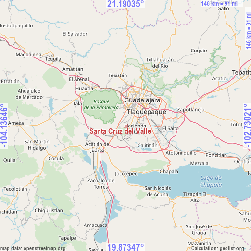
| Map corner | latitude | longitude |
|---|---|---|
| Upper-left | 21.19035°, | -104.13646° |
| Center: | 20.53333°, | -103.43333° |
| Lower-right: | 19.87347°, | -102.73021° |
| Map W x H: | 146.4×146.4 km | = 91×91mi |
| max Lat: | 32.7° ⇑31.4% North |
| Santa Cruz del Valle: | 20.53333° |
| min Lat: | ⇓68.6% South 14.53588° |
| min Long | Santa Cruz del | max Long |
| -117.105° | -103.43333° | -86.73105° |
| W 12%⇐ | ⇒88% E |
Elevation
Elevation of Santa Cruz del Valle is 1567 m = 5141 ft, and this is 313.3 m = 1028 ft above average elevation for this country.
| Max E: |
3497 m = 11473 ft | 45.8% |
| Santa Cruz del Valle | 1567 m 5141 ft | |
| Avg. | 1253.7 m = 4113 ft | |
Min E: |
-1 m = -3 ft | 54.2% |
See also: Mexico elevation on elevation.city.
Geographical zone
Santa Cruz del Valle is located in North Torrid zone (between Equator and Tropic of Cancer). Distance of this Northern Tropic circle is 322.8 km =200.6 mi to North.| Distance of | km | miles | from Santa Cruz del Valle |
|---|---|---|---|
| North Pole | 7724 | 4799.5 | to North |
| Arctic Circle | 5118.1 | 3180.2 | to North |
| Tropic Cancer | 322.8 | 200.6 | to North |
| Equator | 2283.1 | 1418.7 | to South |


Nearby cities:
15 places around Santa Cruz del Valle: (largest is in red/bold)
• Colinas del Roble
4.9 km =3 mi,  131°
131°
• Hacienda los Fresnos
4.5 km =2.8 mi,  110°
110°
• Jardines de San Sebastián
2 km =1.2 mi,  144°
144°
• La Calerilla
4.3 km =2.7 mi,  33°
33°
• La Roca
2.4 km =1.5 mi,  162°
162°
• La Tijera
5.4 km =3.4 mi,  352°
352°
• Lomas de San Agustín
3.6 km =2.2 mi,  259°
259°
• Lomas del Sur
4.8 km =3 mi, 160°
• Los Gavilanes
4.9 km =3 mi,  340°
340°
• Los Magueyes (Fraccionamiento el Sereno)
4.2 km =2.6 mi, 353°
• Nicolás R Casillas
3.7 km =2.3 mi,  292°
292°
• Paseo del Prado
5.8 km =3.6 mi,  53°
53°
• San Sebastián el Grande
0.6 km =0.4 mi,  96°
96°
• Santa Anita
2.2 km =1.4 mi,  330°
330°
• Villas de la Hacienda [Fraccionamiento]
5.3 km =3.3 mi,  92°
92°
Sources, notices
• [Note1] Compared only with cities in Mexico existing in our database
• [Src1] Map data: © OpenStreetMap contributors (CC-BY-SA)
• [Src2] Other city data from geonames.org with taken over terms of usage.
• [Src3] Geographical zone / Annual Mean Temperature by Robert A. Rohde @ Wikipedia
