Paseo del Prado geodata
Paseo del Prado (Jalisco) is a populated place; located in Mexico in America/Mexico_City (GMT-6) time zone. With population of 4,706 people, there are 1964 cities with bigger population in this country. Compared to other cities in Mexico, 69.2% of cities are located further ↓South; 87.7% of cities are located further →East and 53.4% of cities have lower elevation than Paseo del Prado. Note1


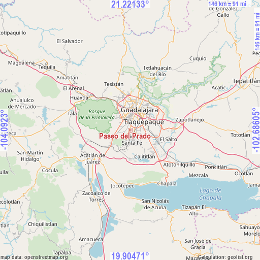
Paseo del Prado GPS coordinates[2]
20° 33' 51.984" North, 103° 23' 21.012" West
| Map corner | latitude | longitude |
|---|---|---|
| Upper-left | 21.22133°, | -104.0923° |
| Center: | 20.56444°, | -103.38917° |
| Lower-right: | 19.90471°, | -102.68605° |
| Map W x H: | 146.4×146.4 km | = 91×91mi |
| max Lat: | 32.7° ⇑30.8% North |
| Paseo del Prado: | 20.56444° |
| min Lat: | ⇓69.2% South 14.53588° |
| min Long | Paseo del Prado | max Long |
| -117.105° | -103.38917° | -86.73105° |
| W 12.3%⇐ | ⇒87.7% E |
Elevation
Elevation of Paseo del Prado is 1549 m = 5082 ft, and this is 295.3 m = 969 ft above average elevation for this country.
| Max E: |
3497 m = 11473 ft | 46.6% |
| Paseo del Prado | 1549 m 5082 ft | |
| Avg. | 1253.7 m = 4113 ft | |
Min E: |
-1 m = -3 ft | 53.4% |
See also: Mexico elevation on elevation.city.
Geographical zone
Paseo del Prado is located in North Torrid zone (between Equator and Tropic of Cancer). Distance of this Northern Tropic circle is 319.4 km =198.5 mi to North.| Distance of | km | miles | from Paseo del Prado |
|---|---|---|---|
| North Pole | 7720.5 | 4797.3 | to North |
| Arctic Circle | 5114.6 | 3178.1 | to North |
| Tropic Cancer | 319.4 | 198.5 | to North |
| Equator | 2286.6 | 1420.8 | to South |


Nearby cities:
15 places around Paseo del Prado: (largest is in red/bold)
• Altus Bosques
1.8 km =1.1 mi,  76°
76°
• Hacienda Santa Fe
5.2 km =3.2 mi,  170°
170°
• Hacienda los Fresnos
5 km =3.1 mi,  184°
184°
• Jardines del Edén
4.5 km =2.8 mi,  142°
142°
• La Arbolada Plus
4 km =2.5 mi, 139°
• La Calerilla
2.2 km =1.4 mi,  273°
273°
• La Tijera
5.7 km =3.5 mi,  289°
289°
• La Unión del Cuatro
4.3 km =2.7 mi,  149°
149°
• Los Magueyes (Fraccionamiento el Sereno)
5.1 km =3.2 mi,  277°
277°
• Real del Valle (El Paraíso) [Fraccionamiento]
2.9 km =1.8 mi, 136°
• San Sebastián el Grande
5.4 km =3.4 mi,  228°
228°
• Santa Rosa (Real Tulipanes) [Fraccionamiento]
1.6 km =1 mi,  55°
55°
• Sendero Real
5.6 km =3.5 mi, 136°
• Valle Dorado Inn
5.3 km =3.3 mi, 147°
• Villas de la Hacienda [Fraccionamiento]
3.8 km =2.4 mi, 169°
Sources, notices
• [Note1] Compared only with cities in Mexico existing in our database
• [Src1] Map data: © OpenStreetMap contributors (CC-BY-SA)
• [Src2] Other city data from geonames.org with taken over terms of usage.
• [Src3] Geographical zone / Annual Mean Temperature by Robert A. Rohde @ Wikipedia
