San Nicolás de los Agustinos geodata
San Nicolás de los Agustinos (Guanajuato) is a populated place; located in Mexico in America/Mexico_City (GMT-6) time zone. With population of 7,148 people, there are 1301 cities with bigger population in this country. Compared to other cities in Mexico, 62.4% of cities are located further ↓South; 73.2% of cities are located further →East and 61.1% of cities have lower elevation than San Nicolás de los Agustinos. Note1
Current local time in San Nicolás de los Agustinos:
06:48 AM, WednesdayDifference from your time zone: hours


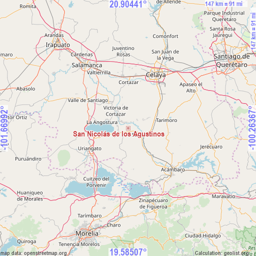
San Nicolás de los Agustinos GPS coordinates[2]
20° 14' 46.104" North, 100° 58' 0.444" West
| Map corner | latitude | longitude |
|---|---|---|
| Upper-left | 20.90441°, | -101.66992° |
| Center: | 20.24614°, | -100.96679° |
| Lower-right: | 19.58507°, | -100.26367° |
| Map W x H: | 146.7×146.7 km | = 91.2×91.2mi |
| max Lat: | 32.7° ⇑37.6% North |
| San Nicolás de los Agustinos: | 20.24614° |
| min Lat: | ⇓62.4% South 14.53588° |
| min Long | San Nicolás de | max Long |
| -117.105° | -100.96679° | -86.73105° |
| W 26.8%⇐ | ⇒73.2% E |
Elevation
Elevation of San Nicolás de los Agustinos is 1746 m = 5728 ft, and this is 492.3 m = 1615 ft above average elevation for this country.
| Max E: |
3497 m = 11473 ft | 38.9% |
| San Nicolás de los Agustinos | 1746 m 5728 ft | |
| Avg. | 1253.7 m = 4113 ft | |
Min E: |
-1 m = -3 ft | 61.1% |
See also: Mexico elevation on elevation.city.
Geographical zone
San Nicolás de los Agustinos is located in North Torrid zone (between Equator and Tropic of Cancer). Distance of this Northern Tropic circle is 354.8 km =220.5 mi to North.| Distance of | km | miles | from San Nicolás de los Agustinos |
|---|---|---|---|
| North Pole | 7755.9 | 4819.3 | to North |
| Arctic Circle | 5150 | 3200.1 | to North |
| Tropic Cancer | 354.8 | 220.5 | to North |
| Equator | 2251.2 | 1398.8 | to South |


Nearby cities:
15 places around San Nicolás de los Agustinos: (largest is in red/bold)
• Cervacio Mendoza
7.4 km =4.6 mi,  234°
234°
• Cupareo
5.7 km =3.5 mi,  250°
250°
• El Capulín
3.8 km =2.4 mi,  329°
329°
• El Potrero
2.9 km =1.8 mi,  45°
45°
• El Sabino
5.4 km =3.4 mi,  316°
316°
• La Luz
7 km =4.3 mi, 47°
• La Quemada
4.8 km =3 mi,  41°
41°
• Maravatío del Encinal
4.6 km =2.9 mi,  173°
173°
• Puerta del Monte
6.3 km =3.9 mi,  282°
282°
• Rancho de Guadalupe
3.9 km =2.4 mi,  24°
24°
• San José del Carmen
8.3 km =5.2 mi,  68°
68°
• San Pedro de los Naranjos
3.7 km =2.3 mi,  124°
124°
• Santa Rita de Casia
5.7 km =3.5 mi,  201°
201°
• Santa Teresa (La Majada)
6.9 km =4.3 mi, 174°
• Santo Tomás Huatzindeo
5.5 km =3.4 mi, 119°
Sources, notices
• [Note1] Compared only with cities in Mexico existing in our database
• [Src1] Map data: © OpenStreetMap contributors (CC-BY-SA)
• [Src2] Other city data from geonames.org with taken over terms of usage.
• [Src3] Geographical zone / Annual Mean Temperature by Robert A. Rohde @ Wikipedia
